Claudy
| Claudy Irish: Clóidigh | |
| County Londonderry | |
|---|---|
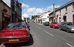
 Main Street in the village | |
| Location | |
| Grid reference: | C541075 |
| Location: | 54°54’44"N, 7°9’26"W |
| Data | |
| Population: | 1,336 (2011) |
| Post town: | Londonderry |
| Postcode: | BT47 |
| Dialling code: | 028 |
| Local Government | |
| Parliamentary constituency: |
East Londonderry |
Claudy is a village and townland (of 1,154 acres) in County Londonderry. It lies in the Faughan Valley, six miles south-east of the county town, Londonderry, where the River Glenrandal joins the River Faughan. It is situated in the parish of Cumber Upper and the barony of Tirkeeran.[1] Its name is from the Irish Clóidigh, meaning "the one who washes/the strong-flowing one".[2]
Claudy had a population of 1,336 people in the 2011 Census.[3] It has two primary schools, two churches and a college named St Patrick's and St Brigid's College.
Sport
- Claudy has a local Gaelic Athletic Association club, Claudy GAC.
- Claudy is home to two rival football clubs, Claudy United and Claudy Rovers.
- The village also has a local leisure centre called the Diamond Centre. It has sporting, gym, and ICT facilities.
References
- ↑ "Claudy". http://www.thecore.com/seanruad/. Retrieved 10 May 2015.
- ↑ "Claudy". http://www.placenamesni.org/resultdetails.php?entry=915. Retrieved 10 May 2015.
- ↑ "Claudy". NI Statistics and Research Agency. http://www.nisra.gov.uk/census/2011/results/settlements.html. Retrieved 10 May 2015.