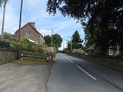
Kinnaird, Atholl
| Kinnaird Gaelic: An Ceann Àrd | |
| Perthshire | |
|---|---|
 Kinnaird | |
| Location | |
| Location: | 56°42’43"N, 3°42’31"W |
| Data | |
| Post town: | Pithlochry |
| Postcode: | PH16 |
| Dialling code: | 01796 |
| Local Government | |
| Council: | Perth & Kinross |
| Parliamentary constituency: |
Perth and North Perthshire |
Kinnaird is a village in Atholl in northern Perthshire. It lies on the Kinnaird Burn, one mile from Pitlochry on the A924 road.[1][2]
There is another Kinnaird in Perthshire, in the Gowrie district in the south of the county.
References
- ↑ Gazetteer for Scotland, http://www.scottish-places.info/towns/townfirst5170.html, retrieved October 20, 2010
- ↑ "Pitlochry and Crieff", Ordnance Survey Landranger Map, 2008, ISBN 0-319-22985-8
| ("Wikimedia Commons" has material about Atholl Kinnaird, Atholl) |
This Perthshire article is a stub: help to improve Wikishire by building it up.
