Kettins
| Kettins | |
| Angus | |
|---|---|
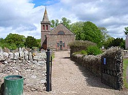
 Kettins Church | |
| Location | |
| Grid reference: | NO238390 |
| Location: | 56°32’13"N, 3°14’26"W |
| Data | |
| Post town: | Blairgowrie |
| Postcode: | PH13 |
| Dialling code: | 01828 |
| Local Government | |
| Council: | Perth and Kinross |
| Parliamentary constituency: |
Perth and North Perthshire |
Kettins is a village and parish in south-western Angus about 14 miles north-east of Perth and 11 miles north-west of Dundee. It is a mile from Coupar Angus, north of the A923 road.[1] With the exception of that part of the parish of Coupar Angus that lies in Angus, the Kettins parish boundary to the north, west and south also forms the county border of Angus with Perthshire. The detached part of Angus locally situate in Perthshire also forms part of the ancient parish.
References
- ↑ "Blairgowrie & Forest of Alyth", Ordnance Survey Landranger Map, 2008, ISBN 0-319-23121-6
| ("Wikimedia Commons" has material about Kettins) |
This Angus article is a stub: help to improve Wikishire by building it up.
