Kersey
| Kersey | |
| Suffolk | |
|---|---|
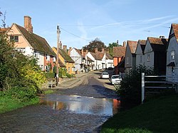
 Kersey ford | |
| Location | |
| Grid reference: | TM000441 |
| Location: | 52°3’34"N, 0°55’0"E |
| Data | |
| Population: | 350 |
| Post town: | Ipswich |
| Postcode: | IP7 |
| Local Government | |
| Council: | Babergh |
Kersey is a small village in Suffolk, though one which made a great impact on the local economy in the Middle Ages.
The village stands across a stream which is a tributary of the River Brett (which it joins half a mile downstream) and the main street of Kersey has a ford across the stream.
The fame of the village is that a coarse woollen cloth called kersey takes its name from this village; it is believed that this cloth originated here before being imitated across the kingdom.
The parish contains the village of Kersey itself and satellite hamlets, namely:
- Kersey Tye
- Kersey Upland
- Wicker Street Green and
- William's Green
The parish church is St Mary's. The village also contains a primary school.
Pictures
 |
 |
Outside links
| ("Wikimedia Commons" has material about Kersey) |
