Caddonfoot
| Caddonfoot Gaelic: Bun Chadain | |
| Selkirkshire | |
|---|---|
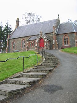
 Caddonfoot Kirk | |
| Location | |
| Grid reference: | NT4476634980 |
| Location: | 55°36’19"N, 2°52’36"W |
| Data | |
| Post town: | Galashiels |
| Postcode: | TD1 |
| Dialling code: | 01896 |
| Local Government | |
| Council: | Scottish Borders |
Caddonfoot is a village and parish on the River Tweed, in Selkirkshire. It is situated on the A707 west of Galashiels. The village itself is at the mouth of the Caddon Water. The surrounding parishes are Stow (in Midlothian) to the north, Melrose (in Roxburghshire) to the north-east, Galashiels to the south-east, Selkirk to the south, Yarrow to the south-west, Traquair (in Peeblesshire) to the west and Innerleithen to the north-west.
As well as the village of Caddonfoot, the parish also encompasses Clovenfords, on the A72 trunk road between Galashiels and Innerleithin.
Outside links
| ("Wikimedia Commons" has material about Caddonfoot) |
- CANMORE/RCAHMS record for Caddonfoot, Manse
- RCAHMS record for Caddonfoot
- SCRAN resource for Caddonfoot
- Gazetteer for Scotland: Caddonfoot
- Caddonfoot War memorial

This Selkirkshire article is a stub: help to improve Wikishire by building it up.
