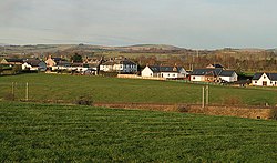
Kirtlebridge
| Kirtlebridge | |
| Dumfriesshire | |
|---|---|

| |
| Location | |
| Grid reference: | NY23817284 |
| Location: | 55°2’38"N, 3°11’35"W |
| Data | |
| Local Government | |
| Council: | Dumfries and Galloway |
| Parliamentary constituency: |
Dumfries and Galloway |
Kirtlebridge is a village in Dumfriesshire. It is to be found a mile south of Eaglesfield and five miles northeast of Annan.
The village sits where the A74(M) motorway and the West Coast Main Line railway cross the Kirtle Water.
Kirtlebridge railway station on the main line formerly served the village, and a nearby junction marked the start of the Solway Junction Railway to Annan.[1] The Kirtlebridge rail crash occurred at the station on 2 October 1872, and resulted in 12 deaths.[2]
| ("Wikimedia Commons" has material about Kirtlebridge) |
References
- ↑ "Caledonian Railway". RAILSCOT. http://www.railbrit.co.uk/Caledonian_Railway/frame.htm.
- ↑ Rolt, L.T.C.; Kichenside, Geoffrey (1982) [1955]. Red for Danger (4th ed.). Newton Abbot: David & Charles. pp. 63–64. ISBN 0-7153-8362-0.
