Camberley
| Camberley | |
| Surrey | |
|---|---|
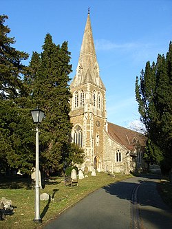
 St Michael's, Camberley | |
| Location | |
| Grid reference: | TQ234561 |
| Location: | 51°20’6"N, -0°44’31"W |
| Data | |
| Population: | 30,155 (2001) |
| Post town: | Camberley |
| Postcode: | GU15-GU17 |
| Dialling code: | 01276 |
| Local Government | |
| Council: | Surrey Heath |
| Parliamentary constituency: |
Surrey Heath |
Camberley is a town in north-western Surrey, in the corridor between the M3 and M4 motorways. The town lies close to the borders of both Hampshire and Berkshire; at the western edge of the town the three counties meet.
Camberley's suburbs include Crawley Hill, Heatherside (despite clearly being separated by the M3 Motorway), Yorktown, Old Dean and Frimley Road district.
The town has a population of 30,155,[1] whilst the Aldershot Urban Area (which also includes other towns, such as Aldershot, Farnborough, and Farnham) has a population of 243,344.[1]
References
- ↑ 1.0 1.1 "Table KS01 Usual resident population". Office for National Statistics. http://www.statistics.gov.uk/statbase/Expodata/Spreadsheets/D8271.csv. Retrieved 2008-05-11.

This Surrey article is a stub: help to improve Wikishire by building it up.