Cox Green, Berkshire
| Cox Green | |
| Berkshire | |
|---|---|
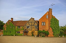
 Lillibrooke Manor | |
| Location | |
| Grid reference: | SU8679 |
| Location: | 51°30’29"N, -0°44’31"W |
| Data | |
| Population: | 7,203 (2001) |
| Post town: | Maidenhead |
| Postcode: | SL6 |
| Dialling code: | 01628 |
| Local Government | |
| Council: | Windsor and Maidenhead |
| Parliamentary constituency: |
Maidenhead |
Cox Green is a village in eastern Berkshire, which is swiftly becoming a mere suburb of the neighbouring town, Maidenhead.
The parish is hemmed in by big roads, bounded by the A4 road to the north and the A404(M) motorway section to the north-east. The M4 motorway runs to the south-east and the only rural boundary is with White Waltham's parish to the west. The original village stood in the area of Cox Green Lane, Cox Green Road and Norden Road, south of the railway.
The second half of the 20th Century saw a rapid expansion of housing, including Woodlands Park to the west, to absorb Cox Green into Maidenhead.
Cox Green School shares a site with the adjacent Community Centre on Highfield Road, providing such local facilities as a library and both indoor and outdoor sports facilities. Additional leisure facilities exist at Ockwells Park, where as well as sports fields and open park and woodland, there is a well-stocked children's play area.
Parish church
The parish church is the Church of the Good Shepherd, located in the Community Centre in Highfield Road.
About the village
The oldest building in the parish is Ockwells Manor, beside Ockwells Park.
A Roman villa was discovered from aerial photographs in the 1950s and was fully excavated in 1959 in advance of the building of the present housing estate.[1]
Outside links
| ("Wikimedia Commons" has material about Cox Green, Berkshire) |
References
- ↑ Cox Green Roman Villa - Royal Berkshire History
