Glyntraian
| Glyntraian | |
| Denbighshire | |
|---|---|
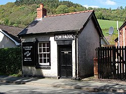
 Former Glyn Valley Tramway waiting room at Pontfadog | |
| Location | |
| Grid reference: | SJ2321637511 |
| Location: | 52°55’45"N, 3°8’33"W |
| Data | |
| Population: | 878 (2001) |
| Post town: | Llangollen |
| Postcode: | LL20 |
| Dialling code: | 01691 |
| Local Government | |
| Council: | Wrexham |
| Parliamentary constituency: |
Clwyd South |
Glyntraian is a parish in eastern Denbighshire adjacent to the border with Shropshire.
The parish of Glyntraian, lying at the mouth of the Ceiriog Valley, was formed when the ancient parish of Llangollen was divided into three traeanau (being the Welsh for "third"): Llangollen Traean, Trefor Traean, and Glyn Traean - which became known as Glyntraian.
It contained the historic townships of Cilcochwyn, Crogeniddon, Crogenwladus, Erwallo, Hafodgynfor, Nantygwryd, Pennant and Talygarth.
Today, Glyntraian contains the villages of Dolywern, Llechrydau, Llwynmawr and Pontfadog. At the 2001 Census, the parish had a total population of 878.[1]
References
- ↑ Glyntraian (Parish), Office for National Statistics
This Denbighshire article is a stub: help to improve Wikishire by building it up.