Dwyriw
| Dwyriw | |
| Montgomeryshire | |
|---|---|

| |
| Location | |
| Grid reference: | SN971902 |
| Location: | 52°36’48"N, 3°22’8"W |
| Data | |
| Population: | 571 |
| Post town: | Newtown |
| Postcode: | SY16 |
| Dialling code: | 01938 |
| Local Government | |
| Council: | Powys |
| Parliamentary constituency: |
Montgomeryshire |
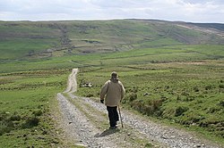
Dwyriw is a parish in Montgomeryshire. It is located between two tributaries of the river Rhiw, hence the name ("Two Rhiw Rivers"), south-west of Llanfair Caereinion.
Historic buildings nearby include Capel Coffa Lewis Evan in Adfa and St. Mary's Church Llanllugan.
The villages within the parish include: Llanllugan, Cefn Coch, Llanwyddelan and Adfa.

This Montgomeryshire article is a stub: help to improve Wikishire by building it up.