Brewlands Bridge
| Brewlands Bridge | |
| Angus | |
|---|---|

| |
| Location | |
| Grid reference: | NO195615 |
| Location: | 56°44’17"N, 3°19’3"W |
| Data | |
| Post town: | Blairgowrie |
| Postcode: | PH11 |
| Dialling code: | 01575 |
| Local Government | |
| Council: | Angus |
| Parliamentary constituency: |
Angus |
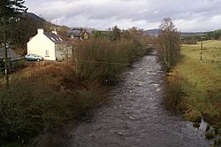
Brewlands Bridge is a hamlet in Glen Isla in Angus. It is to be found on the banks of the River Isla, eleven miles north-west of Kirriemuir and ten miles north of Blairgowrie, on the B951 road.

The original single segmented arch bridge, dating to the early 19th century remains, although it has been bypassed by a modern replacement.[1]
References
- ↑ "Bridge of Brewlands: Old bridge of Brewlands, River Isla", Royal Commission on the Ancient and Historical Monuments of Scotland, Canmore database, http://canmore.rcahms.gov.uk/en/site/29386/details/bridge+of+brewlands/, retrieved April 26, 2011
This Angus article is a stub: help to improve Wikishire by building it up.