Stapleford Tawney
| Stapleford Tawney | |
| Essex | |
|---|---|
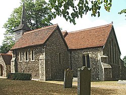
 St Mary's Church, Stapleford Tawney | |
| Location | |
| Grid reference: | TQ502990 |
| Location: | 51°40’12"N, -0°10’18"E |
| Data | |
| Population: | 103 (2001) |
| Post town: | Epping |
| Postcode: | RM4, CM16 |
| Dialling code: | 01992 |
| Local Government | |
| Council: | Epping Forest |
| Parliamentary constituency: |
Brentwood and Ongar |
Stapleford Tawney is a village in Essex, some three miles west of Chipping Ongar and seven miles north of Romford. It is in the Ongar Hundred of the county.
The civil parish of Stapleford Tawney covers an area of 1,656 acres and had a population of 103 in 2001, making it the least populated parish in this part of Essex.
This is a very rural parish, and there is no village or single focus of settlement. Individual farms and houses are scattered throughout the parish. Land use is mostly agricultural. The M25 motorway cuts through the southern tip of the parish.
The parish of Stapleford Tawney with Theydon Mount has two parish churches; St Mary The Virgin, Stapleford Tawney, and St Michael, Theydon Mount.
Geography
The parish is long and narrow, extending roughly three miles from north to south but is generally only about a mile wide for much of its length. Its southern boundary is formed by the River Roding, while a stream flowing into it forms much of the parish’s western boundary. The land rises quite steeply from below 100 metres where the Roding flows into Theydon Mount to above 300 feet in the extreme north.
History
Electricity was first connected to the parish in 1932 and most of the parish was supplied with water by Herts. and Essex Waterworks Co. in 1949. [1]
See also
References
- ↑ 'Stapleford Tawney: Introduction' - A History of the County of Essex: Volume 4: Ongar Hundred (1956), pp. 233-34 (Victoria County History)