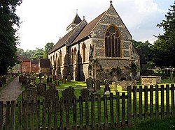
Speen, Berkshire
| Speen | |
| Berkshire | |
|---|---|
 St Mary the Virgin, Speen | |
| Location | |
| Grid reference: | SU4668 |
| Location: | 51°24’18"N, 1°20’49"W |
| Data | |
| Population: | 2,634 (2001) |
| Post town: | Newbury |
| Postcode: | RG14 |
| Dialling code: | 01635 |
| Local Government | |
| Council: | West Berkshire |
| Parliamentary constituency: |
Newbury |
Speen is a village in Berkshire found about two miles northwest of Newbury. It sits on the Ermin Street/Ermin Way, the main Cirencester to Silchester Roman road.
During the Civil War, the Second Battle of Newbury was actually fought at Speen, on 27 October 1644.
Speenhamland in the parish, now absorbed into Newbury, was the eponymous home of the Speenhamland system of outdoor relief.[1]
Speen Recreation Ground on Station Road has been designated a Queen Elizabeth II Field.
Parish church
The parish church is St Mary the Virgin. It is a late Anglo-Saxon church, and is the oldest church in Berkshire.[2]
Speen House
Next to the church and Ladywell are the ramparts around Speen House, the manor house which is mostly late 18th century, but which is thought to date from the 17th century. Local folk belief has it that ramparts are associated with the Roman village of Spinae, but it is more likely that they are associated with a later mediæval manor house.
Outside links
| ("Wikimedia Commons" has material about Speen, Berkshire) |
References
- ↑ A History of the County of Berkshire - Victoria County History vol 4 (1924): Speen with Speenhamland, Bagnor and Benham
- ↑ "St Mary's Church, Speen, Newbury". St-mary-speen.org. http://www.st-mary-speen.org/. Retrieved 21 February 2013.
