Carrick Castle
| Carrick Castle | |
|
Argyllshire | |
|---|---|
 Carrick Castle | |
| Location | |
| Grid reference: | NS193944 |
| Location: | 56°6’31"N, 4°54’25"W |
| History | |
| Information | |
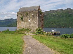
Carrick Castle is a 15th-century tower house on the west shore of Loch Goil in Argyllshire. It stands between Cuilmuich and Carrick, 4 miles south of Lochgoilhead.
The Castle consists of two floors above the central great hall. The building is oblong, 66 feet long by 38 feet wide, with walls seven feet thick. It stands 64 feet high. There is a curiosity – a small chimney is built into a window recess. There is an appendage of a smaller 17th Century structure to the original rectangular tower house.
History
The present ruin is possibly the third occupant of this location. The first may have been a Viking fort.[1] The second structure, and first castle, is believed to have been built in the 12th century. Allegedly a hunting seat of the Scots kings, Carrick was originally a Lamont stronghold.
In the spring of 1307, Robert the Bruce drove Henry Percy from the Castle before conducting a guerrilla war against Edward I of England. Edward had given the castle, which belonged to Robert, to Percy. In 1368 it then passed on to the Campbell Earls of Argyle.
The third structure, the late 15th-century castle, was a royal stronghold, held by the Earls of Argyll as hereditary keepers, and was the symbol and source of their power in South Argyll.[1] It was one of their three chief castles, the other two being Duart and Fincharn.
Mary, Queen of Scots, visited here in 1563.
In 1685, during the rebellion of Archibald Campbell, 9th Earl of Argyll, against King James VII, HMS Kingfisher bombarded the castle, badly damaging the keep, which lost its roof.
The castle was intermittently occupied until it was sold to the Murrays, the Earls of Dunmore.
The keep was a ruin for many years but is now in private ownership and undergoing restoration.
The castle
The castle stands on a rocky peninsula, and was formerly defended to landward by a ditch and drawbridge. The building is around 66 feet by 38 feet, and up to 64 feet high.[1]
Outside links
| ("Wikimedia Commons" has material about Carrick Castle) |
- Carrick Castle, Dark Isle
References
- ↑ 1.0 1.1 1.2 Groome, F.H. (1882–1885). "Carrick". Ordnance Gazetteer of Scotland. Thomas C. Jack. http://www.scottish-places.info/features/featurehistory4668.html. Retrieved 2008-11-21.
- Carrick Castle, Listed Building Report
- G. Ewart and F. Baker. (1996) "Carrick Castle: symbol and source of Campbell power in south Argyll from the 14th to the 17th century", Proceedings of the Society of Antiquaries of Scotland, Vol.128, pp. 937–1016
Coordinates: 56°6′31.73″N 4°54′20.24″W / 56.1088139°N 4.9056222°W
