Kesgrave
| Kesgrave | |
| Suffolk | |
|---|---|
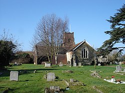
 All Saints Church, Kesgrave | |
| Location | |
| Grid reference: | TM220454 |
| Location: | 52°3’46"N, 1°14’16"E |
| Data | |
| Population: | 11,020 (2005 est.) |
| Post town: | Ipswich |
| Postcode: | IP5 |
| Dialling code: | 01473 |
| Local Government | |
| Council: | East Suffolk |
| Parliamentary constituency: |
Central Suffolk and North Ipswich |
| Website: | Kesgrave Town Council |
Kesgrave is a village in Suffolk, hovering on the northern edge of Ipswich.
The vilage was recorded as Gressgrava in the Domesday Book, by the late 15th century its name had become Kesgrave. Kesgrave remained a small agricultural settlement with just a church, inn and a few farmsteads for over 700 years. In 1921 the population was only 103 housed in 20 dwellings. Since then great changes have taken place, new houses built and a housing estate, influenced by the proximity of Ipswich. Its parish council has elevated itself to the name of "town council".
Today Kesgrave has six schools seerviving the village and the surrounding area; Kesgrave High School has nearly 2000 pupils and there are five primary schools in the immediate vicinity of Kesgrave.