Harworth
| Harworth | |
| Nottinghamshire | |
|---|---|
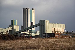
 Harworth Colliery | |
| Location | |
| Grid reference: | SK615915 |
| Location: | 53°25’1"N, 1°4’30"W |
| Data | |
| Post town: | Doncaster |
| Postcode: | DN11 |
| Dialling code: | 01302 |
| Local Government | |
| Council: | Bassetlaw |
| Parliamentary constituency: |
Bassetlaw |
Harworth is a small town in Nottinghamshire, 8 miles north of Worksop. Together with its neighbour mining town of Bircotes, which runs into Harworth, it forms a civil parish named Harworth and Bircotes, with a combined population of nearly 8,000 residents.
The Harworth coal mine used to produce coal for the power stations on the River Trent. The Colliery was 'mothballed' in 2003.
Name
The town's name is from Old English har ("grey"; the modern descendent is 'hoary') and worþ ('enclosure'). The name was recorded as Herwirth in 1136.
Outside links
| ("Wikimedia Commons" has material about Harworth) |
