Kilve
| Kilve | |
| Somerset | |
|---|---|
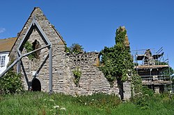
 Remains of Kilve Chantry | |
| Location | |
| Grid reference: | ST149429 |
| Location: | 51°10’45"N, 3°13’6"W |
| Data | |
| Postcode: | TA5 |
| Local Government | |
Kilve is a small village by the coast of Somerset on the Bristol Channel, on the A39, the road which follows the Someset coast. A track from Kilve leads down past the site of the ruined mediæval chantry down past from cottages to the rocky shore. This is where the Quantocks reach the sea. A little to the west is the village of East Quantoxhead.

This Somerset article is a stub: help to improve Wikishire by building it up.