Chulmleigh
| Chulmleigh | |
| Devon | |
|---|---|
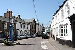
 Main street, Chumleigh | |
| Location | |
| Grid reference: | SS6814 |
| Location: | 50°54’46"N, 3°52’9"W |
| Data | |
| Population: | 1,308 (2001) |
| Post town: | Chulmleigh |
| Postcode: | EX18 |
| Dialling code: | 01769 |
| Local Government | |
| Council: | North Devon |
| Parliamentary constituency: |
North Devon |
Chulmleigh is a remote hilltop village in northern Devon, though a small town by Devon standards. It is located 20 miles northwest of Exeter, out on the A377 and B3096 roads. In 2001 the population of the parish was 1,308.
Chulmleigh has some very old architecture with many cob and thatched buildings. It is located close to the Tarka Railway Line and King's Nympton Railway Station is within the parish, although it is around 2 miles from the village.
The parish church is St Mary Magdalene.
Chulmleigh has a retained a fire station and has a secondary school, Chulmleigh Community College.[1] has been amongst Devon's highest GCSE league tables. The town's pub is the Old Court House.[2] on South Molton Street.
Sport
- Chulmleigh Cricket Club
- Winston Pincombe and Chulmleigh Golf Course
Outside links
References
- ↑ "Chulmleigh Community College". chulmeigh.devon.sch.uk. http://www.chulmleigh.devon.sch.uk.
- ↑ Old Court House