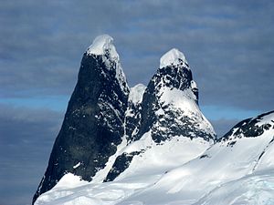
Una Peaks
| Una Peaks | |||
| British Antarctic Territory | |||
|---|---|---|---|
 Una Peaks, January 2010 | |||
| Range: | Graham Land | ||
| Summit: | 2,450 feet 65°1’28"S, 63°46’36"W | ||
Una Peaks, also known as Cape Renard Tower,[1] are two towers of basalt, each topped by a cap of ice, guarding the northern entrance to the Lemaire Channel on the Antarctic Peninsula within the British Antarctic Territory.
The individual towers are referred to as "buttresses".[2] With the highest summit at 2,450 feet.
They peaks were for some years known by the colloquial name of Una's Tits and were even identified as such on some navigation charts. However, the name was not approved by the Antarctic Place Names Committee of the United Kingdom, untl in 2008 the Committee approved the name Una Peaks, "Named for a former secretary in the governor's office, Stanley, Falkland Islands".[3]
The peaks appear on a British Antarctic Territory stamp.
The tallest tower has only been summited once; this was by a German team in 1999.
Outside links
| ("Wikimedia Commons" has material about Una Peaks) |
References
- ↑ American Alpine Club (1998). American Alpine Journal. Seattle, Washington: The Mountaineers Books. p. 136. ISBN 0-930410-78-5.
- ↑ American Alpine Club: American Alpine Journal, 1998 (pub. The Mountaineers Books) ISBN 0-930410-78-5
- ↑ Una Peaks: a long overdue Antarctic geographical naming – Cambridge JournalsPolar Record, September 2008
Sources
- Antarctica. Sydney: Reader's Digest, 1985, pp. 126–127.
- Gazetteer and Map of The British Antarctic Territory: Una Peaks
