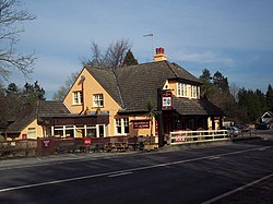
Rake, Sussex
| Rake | |
| Sussex, Hampshire | |
|---|---|
 The Flying Bull, Rake | |
| Location | |
| Grid reference: | SU802277 |
| Location: | 51°2’36"N, -0°51’26"W |
| Data | |
| Postcode: | GU33 |
| Local Government | |
| Council: | Chichester |
| Parliamentary constituency: |
Chichester |
Rake is a little village sitting astride the border of Sussex with Hampshire, at the very north-west of Sussex and the east of Hampshire. The border here runs parallel to the B2070 road between Liphook and Petersfield. Most of the village is on the Sussex side: its single remaining pub, the Flying Bull, formerly named The Two Counties Inn, has the border running through the middle.[1]
Immediately to the south-west, also on the county border, is Hill Brow.
Sport and leisure
Two long-distance walks pass through the village: the Sussex Border Path and the Serpent Trail.