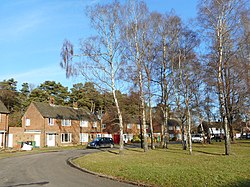
Heath End, Hampshire
| Heath End | |
| Hampshire | |
|---|---|
 Wigmore Road, Heath End | |
| Location | |
| Grid reference: | SU586618 |
| Location: | 51°21’11"N, 1°9’31"W |
| Data | |
| Post town: | Tadley |
| Postcode: | RG26 |
| Dialling code: | 0118 |
| Local Government | |
| Council: | Basingstoke and Deane |
| Parliamentary constituency: |
North West Hampshire |
Heath End is a small village in Hampshire between Tadley and Baughurst, and all of a piece seamlessly with both of them, so that it appears to be no more than a western extension of Tadley.
Church
Heath End has a red brick church, St Mary's which was built in 1874.[1]
Outside links
| ("Wikimedia Commons" has material about Heath End, Hampshire) |
References
- ↑ Nikolaus Pevsner: The Buildings of England: Hampshire & The Isle of Wight, 1967 Penguin Books ISBN 978-0-300-09606-4page 286

