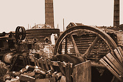
Albert Village
| Albert Village | |
| Leicestershire | |
|---|---|
 Mansfield Brothers, Albert Village | |
| Location | |
| Grid reference: | SK303182 |
| Location: | 52°45’36"N, 1°33’0"W |
| Data | |
| Post town: | Swadlincote |
| Postcode: | DE11 |
| Dialling code: | 01283 |
| Local Government | |
| Council: | North West Leicestershire |
| Parliamentary constituency: |
North West Leicestershire |
Albert Village is a small industrial village in Leicestershire, adjacent to the border with Derbyshire. It is located approximately a mile and a half south of Swadlincote in the latter county. The area's heritage is in coal-mining and pottery manufacture, both locally defunct. The National Forest's visitor attraction 'Conkers' is at nearby Moira.[1] The population is included in the civil parish of Ashby Woulds.
Sport
Albert Village has a children's football team - Albert Village Junior F.C. which caters for boys and girls from the ages of 3–7 years.[2]
References
| ("Wikimedia Commons" has material about Albert Village) |

This Leicestershire article is a stub: help to improve Wikishire by building it up.
