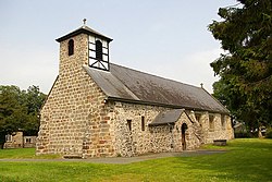
Llandrinio
| Llandrinio | |
| Montgomeryshire | |
|---|---|
 Church of St Trunio | |
| Location | |
| Grid reference: | SJ300170 |
| Location: | 52°44’46"N, 3°2’18"W |
| Data | |
| Post town: | Llanymynech |
| Postcode: | SY22 |
| Dialling code: | 01691 |
| Local Government | |
| Council: | Powys |
| Parliamentary constituency: |
Montgomeryshire |
Llandrinio is a small village in Montgomeryshire, close to the Shropshire border.
Llandrinio is home to about 1,000 people spread over a reasonably large area. The village first had a large population growth by the addition of a council estate many years ago. Soon afterwards a local building contractor bought up some land and constructed a small street of pleasant detached properties, which was extended to add another 12 larger houses to the rear of the street. Another street of approximately 15 houses of ample size has since been added.
The mainly Norman church of St Trunio is a grade II* listed building.[1]
The village has a village hall, often used for car boot sales, and a playing field, which is used by the local cricket team and the junior football teams. The annual carnival has been opened by well-known faces such as actor Ryan Thomas. Nearby is a filling station with a Premier Stores.
The River Severn and Offa's Dyke both run through the village. The river is crossed by a stone bridge, which leads to the hamlet of Crew Green about a mile east of the village. The village is also close to the towns of Welshpool, Oswestry, Newtown and Shrewsbury.
References
- ↑ "Church of St.trunio, B 4393 (S Side), Llandrinio, Llandrinio". British Listed Buildings. http://www.britishlistedbuildings.co.uk/wa-7613-church-of-st-trunio-b-4393-s-side-llandrin. Retrieved 15 December 2013.
Outside links
| ("Wikimedia Commons" has material about Llandrinio) |

This Montgomeryshire article is a stub: help to improve Wikishire by building it up.
