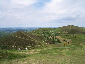
Sugarloaf Hill, Worcestershire
| Sugarloaf Hill | |
| Worcestershire | |
|---|---|
 Sugarloaf Hill (left) with Table Hill and North Hill | |
| Summit: | 1,207 ft[1] 52°6’36"N, 2°20’30"W |
Sugarloaf Hill lies between the Worcestershire Beacon and North Hill in the range of Malvern Hills that runs about eight miles north-south along the Herefordshire-Worcestershire border.
The summit of Sugarloaf Hill is 1,207 ft above sea level and is a popular peak usually passed by walkers hiking between the Worcestershire Beacon and North Hill—respectively the highest and second highest Malvern Hills summits.
References
- ↑ "Identification of key views to and from the Malvern Hills Ares of Outstanding Natural Beauty - A Report prepared by Cooper Partnership for The Malvern Hills AONB Partnership". The Malvern Hills AONB Partnership. March 2009. p. Appendix Table L2: Assessment of Views from and within Malvern Hills AONB. http://www.malvernhillsaonb.org.uk/wp-content/uploads/2015/02/AppendicesA3_000.pdf. Retrieved 11 August 2015.