Walton, Cheshire
| Walton | |
| Cheshire | |
|---|---|
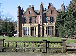
 Walton Hall | |
| Location | |
| Grid reference: | SJ598852 |
| Location: | 53°21’44"N, 2°36’19"W |
| Data | |
| Population: | 1,594 (2001) |
| Post town: | Warrington |
| Postcode: | WA4 |
| Dialling code: | 01925 |
| Local Government | |
| Council: | Warrington |
| Parliamentary constituency: |
Warrington South |
Walton is a village in Cheshire, close to the edge of the southern suburbs attached Warrington, which trespass across the river into Cheshire. Walton sits to the south of the River Mersey (the county border) and south of the Manchester Ship Canal.
Walton is at the southwest edge of urban spread, next to Stockton Heath.
Walton is divided into Lower Walton and Higher Walton. Higher Walton is south-west of Lower Walton, and is the location of Walton Hall. The estate of Walton Hall and its surrounding gardens, previously owned by the Greenall family, was bought by Warrington Borough Council in 1941 and is now a park with a zoo and municipal golf course.[1]
Walton shares its annual church walking day parade with Stockton Heath. The nearest schools are Stockton Heath Primary School and Bridgewater High School.
Miscelllany
Higher Walton was the site of an railway accident. On 29 June 1867 two trains collided at Walton Junction due to signal error. The collision killed eight people and injured 73.[2]
| ("Wikimedia Commons" has material about Walton, Cheshire) |
