Bo'ness
| Borrowstounness | |
| West Lothian | |
|---|---|
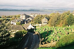
 View over the town looking north | |
| Location | |
| Grid reference: | NS998816 |
| Location: | 56°1’1"N, 3°36’32"W |
| Data | |
| Population: | 14,490 (2001) |
| Post town: | Bo'ness |
| Postcode: | EH51 |
| Dialling code: | 01506 |
| Local Government | |
| Council: | Falkirk |
| Parliamentary constituency: |
Linlithgow and East Falkirk |
Bo'ness, properly Borrowstounness, is a coastal town in West Lothian. It lies on a hillside on the south bank of the Firth of Forth, 17 miles north-west of Edinburgh (in Midlothian) and 7 miles east of Falkirk (in Stirlingshire). At the 2001, Bo'ness had a resident population of 13,961 but recent estimate suggest an increase to about 14,500.
Bo'ness was formerly a centre of heavy industry, coal mining and had a major port. However, the town is now primarily a commuter town.[1]
The town was founded in It has expanded to take in a number of former villages, including Kinneil
The town today includes important archaeological sites
History
Bo'ness has important historical links to the Roman period and marks the eastern extent of the Antonine Wall[2] which stretched from Bo'ness to Old Kilpatrick on the west coast.
Roman artefacts, some with inscriptions, have been found in the eastern part of the town at Carriden. A Roman fort called Veluniate, long since lost to history, once stood on the site now occupied by the grounds of Carriden House. Indeed, it is said that stones from the fort were used in the building of the mansion house. Several artifacts have been uncovered over the years by the local farming community, with many of them now on display in the Museum of Edinburgh. Other Roman sites have been identified at Muirhouses (known locally as "The Murrays") and Kinglass on the south-east side of the town. Kinneil, in the western part of Bo'ness, was mentioned by Bede, who wrote that it was named Peanfahel ("Wall's end") in Pictish and Penneltun in English (Old English). Nennius called it Pengwawl in Old Welsh.
The Antonine Wall was named as an extension to the Frontiers of the Roman Empire World Heritage Site by UNESCO in July 2007. A Roman fortlet can still be seen at Kinneil Estate.[3]
Borrowstounness was founded as a harbour for the village of Borrowstoun: the name is that of the headland, the ness, of Borrowstoun. Borrowstoun itself however has long since been subsumed in its creation, becoming the area of Borrowstoun Mains. Other villages or farmsteads absorbed into Bo'ness include Bridgeness, Grangepans and Kinneil.
The town was a recognised port from the 16th century; a harbour was authorised by an Act of Parliament in 1707. In the 18th century it ranked next to Leith as a port, but the growth of Grangemouth, higher up the firth, seriously affected its shipping trade. The harbour, constructed progressively during the 18th century, was extended and complemented by a dry dock in 1881 (works designed by civil engineers Thomas Meik and Patrick Meik).[4] The commercial port (heavily used for the transport of coal and pit props) eventually closed in 1959, badly affected by silting and the gradual downturn of the Scottish coal mining industry. Plans currently exist for the regeneration of the docks area including reopening the port as a marina.
Bo'ness was a site for coal mining from mediæval times. Clay mining was carried out on a smaller scale. The shore was the site of industrial salt making, evaporating seawater over coal fires. The ruins of several fisheries (fish storage houses) along the shoreline evidences long gone commercial fishing activitiy. The town was also home to several sizable potteries,[5] one exampke of their produce being the black "wally dugs"[6] which sat in pairs over many fireplaces. Metalworking is still carried out, and examples of the Bo'ness Iron Company's work are to be found in many places.[7]
The town today

Bo'ness is now primarily a commuter town, with many of its residents travelling to work in Edinburgh, Glasgow or Falkirk. One of the main local sources of employment is the Ineos petrochemical facility (formerly BP) located in nearby Grangemouth.
Present-day attractions in the town include the Bo'ness & Kinneil Railway and the Birkhill Fireclay Mine. Kinneil House, built by the powerful Hamilton family in the 15th century, lies on the western edge of the town. In the grounds are a cottage where James Watt worked on his experimental steam engine and the steam cylinder of a Newcomen engine. The remains of an engine house are located in Kinningars Park, off Harbour Road.[8]
Churches

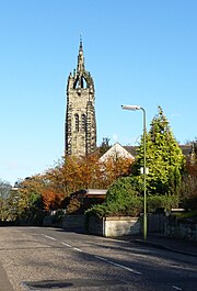
Bo'ness has a number of churches:
- Church of Scotland:
- Bo'ness Old Kirk in Carriden
- St Andrew's Parish Church
- Craigmailen United Free Church
- St. Catharine's Episcopal Church
- Bo'ness Apostolic Church
- Bo'ness Baptist Church
- The Bo'ness Salvation Army
- Roman Catholic: St Mary of the Assumption
As of 2011, consideration is being given to the possible renovation of the town's harbour.
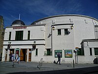
Bo'ness is also home to the recently refurbished 'Hippodrome', which is the oldest picture house in Scotland. The building, along with many other buildings in Bo'ness, was designed by Matthew Steele, a local resident and architect. The Hippodrome was built in 1912.
Sport
- Football:
- Bo'ness United (junior football)
- Bo'ness United Ladies
- Bo'ness United Under 16s
- Rugby: Bo'ness Academy has a rugby team
- Bo'ness Cycling Club, reformed in 2010 as Velo Sport Bo'ness. Jim Smellie was a lesser-known local legend, being an 11 times Scottish Cycling Champion, and some of the trophies collected over the years can be viewed at Kinneil House Museum.[9]
See also
Outside links

- Bo'ness Discussion Board
- Bo'ness community site
- Bo'ness web site
- Proposals by ING to transform the harbour area
- Website on the historical Kinneil Estate, at the western edge of Bo'ness
- Bo'ness Pottery - The Pottery Industry of Borrowstounness 1766 - 1958
- Bo'ness Undiscovered Scotland - The Ultimaate Online Guide
- Boness Pipe band
- National Library of Scotland: SCOTTISH SCREEN ARCHIVE (selection of archive films about Bo’ness)
References
- ↑ Visitors Guide to Linlithgow and Bo'ness
- ↑ http://www.historic-scotland.gov.uk/index/policyandguidance/world_heritage_scotland/antoninewall.htm
- ↑ Kinneil on Undiscovered Scotland
- ↑ Old Bo'ness by Alex F. Young, ISBN 9781840334821
- ↑ Jardine, Robert. "Bo'ness Pottery". http://bonesspottery.com/default.aspx. Retrieved 2007-12-23.
- ↑ "Wemyss Ware". http://www.wemyssware.co.uk/index.php?main_page=index&cPath=31. Retrieved 2011-10-30.
- ↑ http://www.creativeironworks.co.uk/index.php/homepage/show/home/home
- ↑ "Bridgeness, Kinningars Park Dovecot Including Wall and Capped Pit Shaft, Grangepans". http://www.britishlistedbuildings.co.uk/sc-22336-bridgeness-kinningars-park-dovecot-includ. Retrieved 2011-10-29.
- ↑ Smillie, Derek. "Bo'ness Cycling Legend". s1 Bo'ness. http://www.s1boness.com/memories/boness-cycling-legend.html.