Garbh Eileach
| Garbh Eileach Gaelic: Garbh Eileach | |
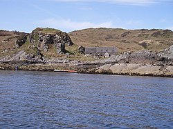
 Bothy on Garbh Eileach | |
|---|---|
| Location | |
| Location: | 56°14’24"N, 5°46’12"W |
| Grid reference: | NM665115 |
| Area: | 351 acres |
| Highest point: | 361 ft |
| Data | |
| Population: | 0 |
Garbh Eileach is an uninhabited island in the Inner Hebrides belonging to Argyllshire. It is the largest of the Garvellachs and lies in the Firth of Lorne between Mull and the Argyll mainland.
The name is Gaelic for "rough rock".[1] The Anglicised version of the name gives the whole group of islands its name, the Garvellachs.
There is a small ruined fort above a bay on the eastern coast.[2]
Footnotes
References
| ("Wikimedia Commons" has material about Garbh Eileach) |
- Mac an Tàilleir, Iain (2003) Ainmean-àite/Placenames. (pdf)

This Argyllshire article is a stub: help to improve Wikishire by building it up.
