Coulsdon
| Coulsdon | |
| Surrey | |
|---|---|
 Old Coulsdon | |
| Location | |
| Grid reference: | TQ298596 |
| Location: | 51°19’16"N, 0°8’19"W |
| Data | |
| Post town: | Coulsdon |
| Postcode: | CR5 |
| Dialling code: | 020, 01737 |
| Local Government | |
| Council: | Croydon |
| Parliamentary constituency: |
Croydon South |
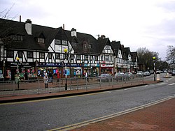
Coulsdon is a town at the edge of the metropolitan conurbation, on the northern edge of the North Downs, surrounded by the Metropolitan Green Belt of the Farthing Down, Coulsdon Common and Kenley Common. The area now known as Coulsdon comprises Old Coulsdon, which was the older and first settlement, and Smitham Bottom, which grew substantially with the coming of the railways.
Its name is pronounced ˈkuːlzdən by the majority of its inhabitants now, although well into the 20th century the local pronunciation was 'Colesdon')
The town is within the Wallington Hundred.
Around Coulsdon are beautiful open spaces over the chalk downlands. Farthing Down and Happy Valley are owned by the City of London Corporation and are popular with walkers. The London Outer Orbital Path ("the London Loop") footpath around London passes through on the route between Hamsey Green and Banstead. The Coulsdon section was the first of the 24 to be opened.
Old Coulsdon

Old CoulsdonTQ315575 is the original village lying a little apart from the modern town, set around Couldson Common.
It has three churches and three parades of shops (Lacey Green, Taunton Lane and Tudor Parade)
Churches
Churches in Coulsdon include:
- Church of England:
- St Andrew's
- St John's (Old Coulsdon)
- Coptic: St Mary and St Shenouda
- Congregational: Old Coulsdon Congregational Church
- Independent evangelical: Coulsdon Christian Fellowship
- Messianic Jewish: Beit Hallel Messianic Synagogue
- Methodist: Brighton Road Methodist Church
- Roman Catholic:
- St Aidan's
- St Mary's (Old Coulsdon)
History
In Coulsdon have been found an Iron Age Field System on Farthing Down and Saxon burial mounds.[1]
In the Domesday Book, the village appears as Colesdone. It had a church and rendered £7[2] to Chertsey Abbey, it has 3½ hides, 7 ploughs, and woodland worth 3 hogs.
Before the Domesday survey, the village's name appears to have gone through a number of changes. Originally it seems to have been Cuðrædsdun ("Cuthred's down") but is found as Curedesdone (675), and later Curresdone and Cullesdune.[3]
The area between Smitham and Old Coulsdon was filled by housing development in the later 19th and especially the 20th centuries. The two centres still, however, have separate characters, with the village green, parade of shops and mediæval church giving a village feel to Old Coulsdon, while the Brighton Road and the railway give the old Smitham Bottom a bustling, busier atmosphere.
Coulsdon and Purley have a local history society called "The Bourne Society", which takes its name from the seasonal bourne that runs in wet winters in the district.
References
Outside links
| ("Wikimedia Commons" has material about Coulsdon) |
