Difference between revisions of "Lisselton"
From Wikishire
(Created page with "{{Infobox town |name=Lisselton |irish=Lios Eiltín |county=Kerry |picture=Lisselton, Saint Teresa's Church.jpg |picture caption=St Teresa's Church, Lisselton |os grid ref=Q930...") |
(No difference)
|
Latest revision as of 12:58, 8 October 2024
| Lisselton Irish: Lios Eiltín | |
| County Kerry | |
|---|---|
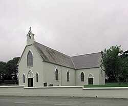
 St Teresa's Church, Lisselton | |
| Location | |
| Grid reference: | Q930385 |
| Location: | 52°29’17"N, 9°34’35"W |
| Data | |
| Local Government | |
| Council: | Listowel |
| Dáil constituency: |
Kerry |
Lisselton is a village in County Kerry.[1] It is located five miles north-west of Listowel on the R553 road to Ballybunion. It has three pubs, several shops and there are two primary schools in the parish.
The name of the village is from the Irish Lios Eiltín, meaning "Ring-fort of Eiltín'.[2]
About the village
The Lartigue Monorail passed through Lisselton between 1888 and 1924.
The village contains three pubs (Cantillons, Tomáisín's and The Thatch Bar), a church, a supermarket/post office and a butchers. There are about 50 houses in the village itself, and two primary schools in the parish.
Lisselton Grotto was built in 1954, the Marian Year. It was later refurbished as part of the work carried out by members of the local FÁS scheme.
Sport
- Gaelic Athletics: Ballydonoghue GAA
- Football: Lisselton Rovers
References
- ↑ "Placenames Database of Ireland". Dublin City University. http://www.. Retrieved 29 October 2014.
- ↑ Lios Eiltín / Lisselton: Placenames Database of Ireland