Monkwearmouth: Difference between revisions
No edit summary |
No edit summary |
||
| Line 15: | Line 15: | ||
'''Monkwearmouth''' is a village of [[County Durham]] which has over the years become merged in with [[Sunderland]] such that it is a suburb of that city. Monkwearmouth stands at the north side of the mouth of the [[River Wear]]. | '''Monkwearmouth''' is a village of [[County Durham]] which has over the years become merged in with [[Sunderland]] such that it is a suburb of that city. Monkwearmouth stands at the north side of the mouth of the [[River Wear]]. | ||
This was one of the three original settlements on the banks of the River Wear along with [[Bishopwearmouth]] and Sunderland, the area now known as the East End. It includes the area around St Peter's Church, founded in 674 as part of [[ | This was one of the three original settlements on the banks of the River Wear along with [[Bishopwearmouth]] and Sunderland, the area now known as the East End. It includes the area around St Peter's Church, founded in 674 as part of [[Monkwearmouth–Jarrow Abbey]], and was once the main centre of Wearside shipbuilding and coalmining in the town. It is now host to a campus of the University of Sunderland and the National Glass Centre. It is served by the three [[Church of England]] churches of the Parish of Monkwearmouth. | ||
The locals of the area were called "Barbary Coasters". The borough stretches from Wearmouth Bridge to the harbour mouth on the north side of the river and is one of the oldest parts of Sunderland. | The locals of the area were called "Barbary Coasters". The borough stretches from Wearmouth Bridge to the harbour mouth on the north side of the river and is one of the oldest parts of Sunderland. | ||
Latest revision as of 22:14, 11 August 2024
| Monkwearmouth | |
| County Durham | |
|---|---|
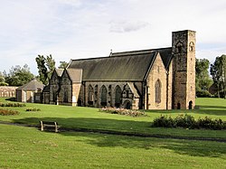
 St Peter's Church | |
| Location | |
| Grid reference: | NZ350549 |
| Location: | 54°54’53"N, 1°22’57"W |
| Data | |
| Post town: | Sunderland |
| Postcode: | SR5, SR6 |
| Dialling code: | 0191 |
| Local Government | |
| Council: | City of Sunderland |
| Parliamentary constituency: |
Sunderland North |
Monkwearmouth is a village of County Durham which has over the years become merged in with Sunderland such that it is a suburb of that city. Monkwearmouth stands at the north side of the mouth of the River Wear.
This was one of the three original settlements on the banks of the River Wear along with Bishopwearmouth and Sunderland, the area now known as the East End. It includes the area around St Peter's Church, founded in 674 as part of Monkwearmouth–Jarrow Abbey, and was once the main centre of Wearside shipbuilding and coalmining in the town. It is now host to a campus of the University of Sunderland and the National Glass Centre. It is served by the three Church of England churches of the Parish of Monkwearmouth.
The locals of the area were called "Barbary Coasters". The borough stretches from Wearmouth Bridge to the harbour mouth on the north side of the river and is one of the oldest parts of Sunderland.
The former railway station, closed in 1968 by the Beeching Axe, is now the Monkwearmouth Station Museum and features a restored booking office dating from the Edwardian period. Since 2002 Monkwearmouth has once again been served by rail transport, this time by way of St Peter's metro station a few hundred yards south of the old station.
The area is also the home of the Stadium of Light, which was opened on the site of the abandoned Wearmouth Colliery in July 1997, and is the home of the football club Sunderland AFC, who had previously played at Roker Park.
Wearmouth Colliery was closed in December 1993, and had been in operation for over 100 years.
Outside links
| ("Wikimedia Commons" has material about Monkwearmouth) |
