Difference between revisions of "Tansor"
From Wikishire
(Created page with "{{Infobox town |name=Tansor |county=Northamptonshire |picture=The Church of St Mary the Virgin at Tansor - geograph.org.uk - 321353.jpg |picture caption=The Church of St Mary...") |
(No difference)
|
Latest revision as of 19:31, 5 February 2024
| Tansor | |
| Northamptonshire | |
|---|---|
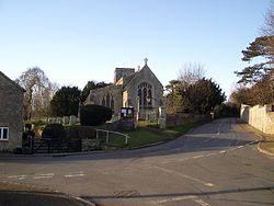
 The Church of St Mary the Virgin at Tansor | |
| Location | |
| Grid reference: | TL054910 |
| Location: | 52°30’26"N, 0°26’51"W |
| Data | |
| Population: | 172 (2011) |
| Post town: | Peterborough |
| Postcode: | PE8 |
| Dialling code: | 01832 |
| Local Government | |
| Council: | North Northamptonshire |
| Parliamentary constituency: |
Corby |
Tansor is a village in Northamptonshire, close by the River Nene, three miles north-east of the Oundle and a mile from its neighbouring village, Cotterstock.
The parish church, St Mary the Virgin, is Grade II* listed.
The 2011 Census recorded the parish's population as 172.
The village's name origin is dubious. 'Tan's ridge' or maybe, 'Tan's river bank'.[1]
Society
There is a village hall in Tansor, from which a playgroup operates.
| ("Wikimedia Commons" has material about Tansor) |