Difference between revisions of "Snorscombe"
From Wikishire
(Created page with "{{Infobox town |name=Snorscombe |county=Northamptonshire |picture=Snorscomb Farm buildings (geograph 3320657).jpg |picture caption= |os grid ref=SP597562 |latitude=52.2050442...") |
(No difference)
|
Latest revision as of 21:32, 1 February 2024
| Snorscombe | |
| Northamptonshire | |
|---|---|

| |
| Location | |
| Grid reference: | SP597562 |
| Location: | 52°12’18"N, 1°3’54"W |
| Data | |
| Local Government | |
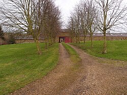
Snorscombe is a ruined hamlet south of Everdon in Northamptonshire whose rural location, now on private land, makes it extremely hard to access.
History
The hamlet was once a thriving community. The mediæval residents would have worked for the local Lord under the manorial system and cultivated the surrounding land. The manor at Snorscombe was held by a Philip Lovell at the time of King John. By 1534 it had passed to the Knightley family.
The manor house was a farmhouse by the early 18th century and all that was left of the village was that farm, a watermill and a cottage.