Bulwick: Difference between revisions
Jump to navigation
Jump to search
Created page with "{{Infobox town |name=Bulwick |county=Northamptonshire |picture=Queens Head, Bulwick.jpg |picture caption=The Queen's Head |os grid ref= SP962942 |latitude=52.5373 |longitude=-..." |
No edit summary |
||
| Line 3: | Line 3: | ||
|county=Northamptonshire | |county=Northamptonshire | ||
|picture=Queens Head, Bulwick.jpg | |picture=Queens Head, Bulwick.jpg | ||
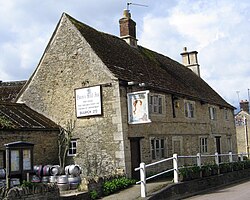
|picture caption=The Queen's Head | |picture caption=The Queen's Head, Bulwick | ||
|os grid ref= SP962942 | |os grid ref= SP962942 | ||
|latitude=52.5373 | |latitude=52.5373 | ||
Revision as of 23:24, 16 January 2024
| Bulwick | |
| Northamptonshire | |
|---|---|
 The Queen's Head, Bulwick | |
| Location | |
| Grid reference: | SP962942 |
| Location: | 52°32’14"N, -0°34’56"W |
| Data | |
| Population: | 171 (2011) |
| Post town: | Corby |
| Postcode: | NN17 |
| Dialling code: | 01780 |
| Local Government | |
| Council: | North Northamptonshire |
| Parliamentary constituency: |
Corby |
Bulwick is a small village in Northamptonshire, about six miles north-east of Corby, just off the A43 road. The Willow Brook runs through the village. The 2011 recorded a population of 171

The village's name means 'bull specialised farm'.[1]
The village Church of England parish church is St Nicholas.
Nearby are Bulwick Meadows, a Site of Special Scientific Interest.
Outside links
| ("Wikimedia Commons" has material about Bulwick) |
