Welcome Islands: Difference between revisions
Jump to navigation
Jump to search
No edit summary |
No edit summary |
||
| Line 11: | Line 11: | ||
The islands are to the east of [[Bird Island, South Georgia|Bird Island]] and west of the [[Bay of Isles]], 4 miles west-northwest of [[Cape Buller]]. The Welcome Islands were discovered and charted by Captain James Cook in January 1775.<ref>Journal of Captain James Cook's, 1775, ed. Beaglehole, 1961, p. 621</ref> | The islands are to the east of [[Bird Island, South Georgia|Bird Island]] and west of the [[Bay of Isles]], 4 miles west-northwest of [[Cape Buller]]. The Welcome Islands were discovered and charted by Captain James Cook in January 1775.<ref>Journal of Captain James Cook's, 1775, ed. Beaglehole, 1961, p. 621</ref> | ||
The name dates back to at least 1912 and is now well established. It may refer to a feature of the largest of the islands, which has a natural arch some | The name dates back to at least 1912 and is now well established. It may refer to a feature of the largest of the islands, which has a natural arch some 295 feet high; the highest point of the islands. | ||
==Outside links== | ==Outside links== | ||
{{basgaz}} | *{{basgaz}} | ||
*[http://encarta.msn.com/map_701560124/Willis_Islands.html Map of Willis Islands, Bird Island and Welcome Islands] | *[http://encarta.msn.com/map_701560124/Willis_Islands.html Map of Willis Islands, Bird Island and Welcome Islands] | ||
Latest revision as of 10:46, 26 March 2023
| Welcome Islands | |
| Location | |
| Location: | 53°58’30"S, 37°29’32"W |
| Data | |
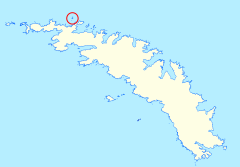
The Welcome Islands are a small rocky archipelago to the north of the island of South Georgia, within the territory of South Georgia and the South Sandwich Islands.
The islands are to the east of Bird Island and west of the Bay of Isles, 4 miles west-northwest of Cape Buller. The Welcome Islands were discovered and charted by Captain James Cook in January 1775.[1]
The name dates back to at least 1912 and is now well established. It may refer to a feature of the largest of the islands, which has a natural arch some 295 feet high; the highest point of the islands.
Outside links
- Gazetteer and Map of South Georgia and the South Sandwich Islands: Welcome Islands
- Map of Willis Islands, Bird Island and Welcome Islands
References
- ↑ Journal of Captain James Cook's, 1775, ed. Beaglehole, 1961, p. 621
