Eridge: Difference between revisions
Redirected page to Rotherfield#Eridge |
No edit summary |
||
| Line 1: | Line 1: | ||
{{Infobox town | |||
|name=Eridge | |||
|county=Sussex | |||
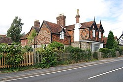
|picture=Ebenezer Cottage, Eridge Green - geograph.org.uk - 1492820.jpg | |||
|picture caption=Ebenezer Cottage, Eridge | |||
|os grid ref= | |||
|latitude= | |||
|longitude= | |||
|population= | |||
|census year= | |||
|post town= | |||
|postcode= | |||
|dialling code= | |||
|LG district= | |||
|constituency= | |||
}} | |||
'''Eridge''' or '''Eridge Green''' is a small village, on a sandstone ridge close to the borders of [[Kent]]. Around the village are some publicly accessible woodland and trails with far-reaching views across the Kent and Sussex countryside. | |||
[[ | The A26 road between [[Royal Tunbridge Wells|Tunbridge Wells]] and [[Crowborough]] passes through the village. | ||
The name Eridge is thought to derive from 'Eagle ridge'.<ref>{{placenames|p=53}}</ref> It is directly north of Rotherfield, and largely overlaps the ecclesiastical parish of Eridge Green. | |||
==Parish church== | |||
On the village street is the church which is Grade II listed,<ref>{{NHLE|1028329|Holy Trinity Church|grade=II}}</ref> | |||
The church was built in 1852-1856 in a 14th-century Gothic style. Stone. The interior was remodelled in 1950, with fittings designed by John L Denman. | |||
==About the village== | |||
Here are [[Eridge Park]] and Eridge Castle, the latter being the seat of the Earl and Marquess of Abergavenny. a mainline railway station (Eridge) and six other listed buildings including the public house, the ''Neville Crest and Gun''. In 1792 Henry Nevill, 2nd Earl of Abergavenny converted the old Eridge House into a Gothic castle, which he named "Eridge Castle". It was replaced by a Neo-Georgian mansion in the 1930s after the original structure was badly damaged by fire. The area also contains several follies, including the Saxonbury Tower and several ornamental buildings near the Sham Farm business park. The undulating park and garden of Eridge Park is densely wooded to its north (Whitehill Wood) and south (Saxonbury Hill) and for its landscape it is rated Grade II* on the Register of Parks and Gardens.<ref>{{NHLE|1000265|Eridge Park|type=garden}}</ref> | |||
==Leisure, culture and sport== | |||
[[File:Eridge Rocks - geograph.org.uk - 2306241.jpg|right|thumb|200px|Eridge Rocks]] | |||
In the Eridge area lies one of several local sandstone outcrops used for climbing.<ref>{{cite web|url=http://www.climb-guide.com/guides/ssand/sscrags/eridge.htm|title=Eridge Green Rocks|work=Climb-Guide climbing wiki|access-date=2 November 2011}}</ref> | |||
{{commons}} | |||
==References== | |||
{{reflist}} | |||
Latest revision as of 13:34, 1 February 2023
| Eridge | |
| Sussex | |
|---|---|
 Ebenezer Cottage, Eridge | |
| Location | |
| Data | |
| Local Government |
Eridge or Eridge Green is a small village, on a sandstone ridge close to the borders of Kent. Around the village are some publicly accessible woodland and trails with far-reaching views across the Kent and Sussex countryside.
The A26 road between Tunbridge Wells and Crowborough passes through the village.
The name Eridge is thought to derive from 'Eagle ridge'.[1] It is directly north of Rotherfield, and largely overlaps the ecclesiastical parish of Eridge Green.
Parish church
On the village street is the church which is Grade II listed,[2]
The church was built in 1852-1856 in a 14th-century Gothic style. Stone. The interior was remodelled in 1950, with fittings designed by John L Denman.
About the village
Here are Eridge Park and Eridge Castle, the latter being the seat of the Earl and Marquess of Abergavenny. a mainline railway station (Eridge) and six other listed buildings including the public house, the Neville Crest and Gun. In 1792 Henry Nevill, 2nd Earl of Abergavenny converted the old Eridge House into a Gothic castle, which he named "Eridge Castle". It was replaced by a Neo-Georgian mansion in the 1930s after the original structure was badly damaged by fire. The area also contains several follies, including the Saxonbury Tower and several ornamental buildings near the Sham Farm business park. The undulating park and garden of Eridge Park is densely wooded to its north (Whitehill Wood) and south (Saxonbury Hill) and for its landscape it is rated Grade II* on the Register of Parks and Gardens.[3]
Leisure, culture and sport

In the Eridge area lies one of several local sandstone outcrops used for climbing.[4]
| ("Wikimedia Commons" has material about Eridge) |
References
- ↑ Mawer, A.; Stenton, F.M.; with Gover, J. E. B.: 'Place-Names of Sussex , Part' (English Place-Names Society, 1929/30), page 53
- ↑ National Heritage List 1028329: Holy Trinity Church (Grade II listing)
- ↑ National Heritage List 1000265: Eridge Park (Register of Historic Parks and Gardens)
- ↑ "Eridge Green Rocks". Climb-Guide climbing wiki. http://www.climb-guide.com/guides/ssand/sscrags/eridge.htm.
