Farleigh Hill: Difference between revisions
Jump to navigation
Jump to search
Created page with "{{Infobox hill |name=Farleigh Hill |county=Hampshire |picture=Farleigh Hill top - geograph.org.uk - 1766545.jpg |picture caption=Road at the summit of Farleigh Hill as it begi..." |
No edit summary |
||
| Line 3: | Line 3: | ||
|county=Hampshire | |county=Hampshire | ||
|picture=Farleigh Hill top - geograph.org.uk - 1766545.jpg | |picture=Farleigh Hill top - geograph.org.uk - 1766545.jpg | ||
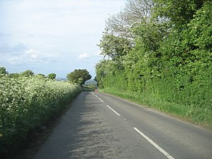
|picture caption=Road at the summit of Farleigh Hill | |picture caption=Road at the summit of Farleigh Hill | ||
|os grid ref=SU616472 | |os grid ref=SU616472 | ||
|latitude=51.2207 | |latitude=51.2207 | ||
Latest revision as of 14:07, 1 October 2022
| Farleigh Hill | |||
| Hampshire | |||
|---|---|---|---|
 Road at the summit of Farleigh Hill | |||
| Range: | Hampshire Downs | ||
| Summit: | 682 feet SU616472 51°13’15"N, 1°7’6"W | ||
Farleigh Hill is a hill in Hampshire, amongst the Hampshire Downs, which reaches a height of 682 feet above sea level.
The hill rises about half a mile south-east of the M3 motorway and the outskirts of Basingstoke in the north of the county. The B3046 road runs over the hill from south-west to north-east, passing within about 100 yards of the summit at a crossroads.
In the vicinity are a number of houses and lodges, and Farleigh House School and Farleigh Wallop lie on the south-eastern spur of the hill. The village of Cliddesden lies on the same road about a mile to the north-east.