South Allington: Difference between revisions
Jump to navigation
Jump to search
Created page with "{{Infobox town |name=South Allington |county=Devon |picture=The Crossroads at South Allington - geograph.org.uk - 1768923.jpg |picture caption=The Crossroads in South Allingto..." |
No edit summary |
||
| Line 17: | Line 17: | ||
'''South Allington''' is a hamlet in the very south of [[Devon]], less than a mile east of [[Chivelstone]], a hamlet of siimliar size and in whose parish South Allington falls, in ecclesiastical and civil terms. | '''South Allington''' is a hamlet in the very south of [[Devon]], less than a mile east of [[Chivelstone]], a hamlet of siimliar size and in whose parish South Allington falls, in ecclesiastical and civil terms. | ||
The hamlet is in the very south of Devon, close to both [[Start Point]] and [[Prawle Point]] – the latter the county’s southernmost headland. | The hamlet is in the very south of Devon, close to both [[Start Point, Devon|Start Point]] and [[Prawle Point]] – the latter the county’s southernmost headland. | ||
==Outside links== | ==Outside links== | ||
{{commons}} | {{commons}} | ||
Latest revision as of 15:42, 28 February 2021
| South Allington | |
| Devon | |
|---|---|
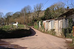
 The Crossroads in South Allington | |
| Location | |
| Grid reference: | SX793386 |
| Location: | 50°14’9"N, 3°41’36"W |
| Data | |
| Post town: | Kingsbridge |
| Postcode: | TQ7 |
| Local Government | |
| Council: | South Hams |
South Allington is a hamlet in the very south of Devon, less than a mile east of Chivelstone, a hamlet of siimliar size and in whose parish South Allington falls, in ecclesiastical and civil terms.
The hamlet is in the very south of Devon, close to both Start Point and Prawle Point – the latter the county’s southernmost headland.
Outside links
| ("Wikimedia Commons" has material about South Allington) |
