Carmunnock: Difference between revisions
Created page with "{{Infobox town |county=Lanarkshire |picture=Carmunnock Parish Church (The Kirk o' the Braes).jpg |picture caption=Carmunnock Parish Church |population=1,106 |gaelic=Cathair Mh..." |
m →Transport: clean up, replaced: train station → railway station |
||
| Line 26: | Line 26: | ||
==Transport== | ==Transport== | ||
The village's only public transport link is the number 31 bus service to [[Glasgow]] City Centre and East Kilbride.<ref>{{cite web|publisher=First Bus Glasgow Online|title =31 Bus Timetable| url=http://www.firstgroup.com/ukbus/glasgow/journey_planning/timetables/index.php?operator=10&service=31&page=1&redirect=no| year = 2013| accessdate =2013-02-24 }}</ref> The nearest | The village's only public transport link is the number 31 bus service to [[Glasgow]] City Centre and East Kilbride.<ref>{{cite web|publisher=First Bus Glasgow Online|title =31 Bus Timetable| url=http://www.firstgroup.com/ukbus/glasgow/journey_planning/timetables/index.php?operator=10&service=31&page=1&redirect=no| year = 2013| accessdate =2013-02-24 }}</ref> The nearest railway station is at Busby, which is on the East Kilbride to Glasgow line. | ||
The main route through the village is the B759 which runs from [[Busby]] to [[Cambuslang]]. | The main route through the village is the B759 which runs from [[Busby]] to [[Cambuslang]]. | ||
Latest revision as of 20:29, 29 January 2021
| Carmunnock Gaelic: Cathair Mhanach or Coire Manaich | |
| Lanarkshire | |
|---|---|
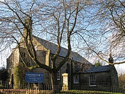
 Carmunnock Parish Church | |
| Location | |
| Grid reference: | NS598574 |
| Location: | 55°47’22"N, 4°14’15"W |
| Data | |
| Population: | 1,106 |
| Post town: | Glasgow |
| Postcode: | G76 |
| Dialling code: | 0141 |
| Local Government | |
| Council: | Glasgow |
| Parliamentary constituency: |
Glasgow South |
Carmunnock is a conservation-area village and parish in Lanarkshire within the city of Glasgow. It lies within three miles of East Kilbride and Rutherglen in Lanarkshire and Busby, Renfrewshire.
This ancient settlement which is associated with the early Christian missionary Saint Cadoc, has a mediæval street plan set within the lands of an estate held by variously the Morays of Bothwell, the Earls of Douglas and eventually to the Lords, Marquesses and Dukes of Hamilton until 1700 when it passed to the Stuarts of Castlemilk.
The village is a popular residential area. The village has its own primary school (Carmunnock Primary School) with around 178 pupils.[1] There is also a newsagent/village shop, a petrol station, a teashop, a pharmacy and a restaurant.
Religion
The only religious body in Carmunnock is the Church of Scotland's Carmunnock Parish Church on Kirk Road, which is also known as 'The Kirk in the Braes'. The original church was built on site of the current Church around 800 years ago, with the current building being built in 1767 in the Civil Parish of Carmunnock.[2] The church features external stone staircases to three galleries within the sanctuary and contains examples of stained glass by Norman Macleod MacDougall.
The church is surrounded by the old village graveyard which includes a watch-house with original instructions for grave watchers of 1828, when grave robbing was a problem. Within the structure of the church is a vault where some members of the Stirling-Stewart family, the Lairds of Castlemilk, are buried.
Transport
The village's only public transport link is the number 31 bus service to Glasgow City Centre and East Kilbride.[3] The nearest railway station is at Busby, which is on the East Kilbride to Glasgow line.
The main route through the village is the B759 which runs from Busby to Cambuslang.
Etymology
Carmunnock is of Brythonic origin, from Celtic caer "fort" with an unknown second element. The name was recorded as Cerminok in 1183.
References
- ↑ "Carmunnock Primary School". H.M.I.E. 2011-02-08. http://www.educationscotland.gov.uk/Images/CarmunnockPrimarySchIns20110207_tcm4-703478.pdf. Retrieved 2013-02-24.
- ↑ The Imperial gazetteer of Scotland. 1854. Vol.I. (AAN-GORDON) by Rev. John Marius Wilson. p.248. http://archive.org/stream/imperialgazettee01wils#page/248/mode/1up
- ↑ "31 Bus Timetable". First Bus Glasgow Online. 2013. http://www.firstgroup.com/ukbus/glasgow/journey_planning/timetables/index.php?operator=10&service=31&page=1&redirect=no. Retrieved 2013-02-24.
This Lanarkshire article is a stub: help to improve Wikishire by building it up.