Taynton, Gloucestershire: Difference between revisions
Created page with "{{Infobox town |name=Taynton |county=Gloucestershire |picture=Taynton Church - geograph.org.uk - 435934.jpg |picture caption=St Lawrence, Taynton |os grid ref=SO727217 |latitu..." |
No edit summary |
||
| Line 23: | Line 23: | ||
==Parish church== | ==Parish church== | ||
The original parish church was recorded in the mid-12th century. Along with the nearby rectory it was destroyed during the Civil War by Royalist forces after the siege of Gloucester in 1643. The site is visible as earthen mounds and a moat at Little Taynton, about a mile and a half north-east of the centre of Taynton village.<ref | The original parish church was recorded in the mid-12th century. Along with the nearby rectory it was destroyed during the Civil War by Royalist forces after the siege of Gloucester in 1643. The site is visible as earthen mounds and a moat at Little Taynton, about a mile and a half north-east of the centre of Taynton village.<ref name=vch/> | ||
Today's parish church, St Lawrence, is located about 1,100 yards north-east of the village centre. It is a Grade II listed building as a rare example of a church built during the Commonwealth. It was originally constructed as a single room preaching-box by order of the Rump Parliament in 1650,<ref name=nhc>{{NHLE|1152696|Church of St Lawrence}}</ref> but it received several 19th century alterations and expansions which converted it into a conventionally formed church.<ref name=vch/> | Today's parish church, St Lawrence, is located about 1,100 yards north-east of the village centre. It is a Grade II listed building as a rare example of a church built during the Commonwealth. It was originally constructed as a single room preaching-box by order of the Rump Parliament in 1650,<ref name=nhc>{{NHLE|1152696|Church of St Lawrence}}</ref> but it received several 19th century alterations and expansions which converted it into a conventionally formed church.<ref name=vch/> | ||
Latest revision as of 23:52, 29 February 2020
| Taynton | |
| Gloucestershire | |
|---|---|
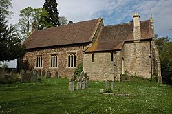
 St Lawrence, Taynton | |
| Location | |
| Grid reference: | SO727217 |
| Location: | 51°53’38"N, 2°23’53"W |
| Data | |
| Population: | 438 (2011) |
| Post town: | Gloucester |
| Postcode: | GL19 |
| Dialling code: | 01452 |
| Local Government | |
| Council: | Forest of Dean |
| Parliamentary constituency: |
Forest of Dean |
Taynton is a village in Gloucestershire, close the border of Herefordshire. The village stands about two and a half miles south-east of Newent and two miles north-east of Mitcheldean. The county town, Gloucester is seven miles to the east.
In 1870-72, John Marius Wilson recorded the population as 689;[1] but by the time of the 2011 Census, the population of the parish had fallen to 438.
Parish
The present-day parish of Taynton was formed of the manors of Great and Little Taynton. As well as Taynton itself, there are several hamlets and scattered farmsteads in the parish. They include Glasshouse, Hownhall, Kent's Green, Little Taynton and Moorend Green. Glasshouse is on the site of a 16th-century glassworks.[1]
Parish church
The original parish church was recorded in the mid-12th century. Along with the nearby rectory it was destroyed during the Civil War by Royalist forces after the siege of Gloucester in 1643. The site is visible as earthen mounds and a moat at Little Taynton, about a mile and a half north-east of the centre of Taynton village.[1]
Today's parish church, St Lawrence, is located about 1,100 yards north-east of the village centre. It is a Grade II listed building as a rare example of a church built during the Commonwealth. It was originally constructed as a single room preaching-box by order of the Rump Parliament in 1650,[2] but it received several 19th century alterations and expansions which converted it into a conventionally formed church.[1]
About the village
There are 31 Grade II listed buildings in the parish. As well as the church and several monuments within it, there are numerous farm buildings, barns and cottages that range between 200 and 400 years old. They include Taynton Court at Kent's Green, and Taynton House in Taynton; both are enlarged buildings with parts that date back to 17th century farmhouses.
Outside links
References
- ↑ 1.0 1.1 1.2 1.3 A History of the County of Gloucester - Volume 12 pp 317-346: Taynton (Victoria County History)
- ↑ National Heritage List 1152696: Church of St Lawrence