Upottery: Difference between revisions
Jump to navigation
Jump to search
Created page with "{{Infobox town |county=Devon |picture=Upottery church (geograph 2571041).jpg |picture caption=St Mary's, Upottery |os grid ref=ST202076 |latitude=50.863 |longitude=-3.135 |na..." |
No edit summary |
||
| Line 14: | Line 14: | ||
|constituency= | |constituency= | ||
}} | }} | ||
'''Upottery''' (originally '''Up Ottery''') is a small village in easter [[Devon]]. It stands in the valley of the [[River Otter, Devon|River Otter]], from which it derives its name, | '''Upottery''' (originally '''Up Ottery''') is a small village in easter [[Devon]]. It stands in the valley of the [[River Otter, Devon|River Otter]], from which it derives its name, in the [[Axminster Hundred]]. | ||
The Census in 2011 recorded the population of the parish as 701. | The Census in 2011 recorded the population of the parish as 701. | ||
Revision as of 15:52, 14 December 2019
| Upottery | |
| Devon | |
|---|---|
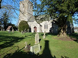
 St Mary's, Upottery | |
| Location | |
| Grid reference: | ST202076 |
| Location: | 50°51’47"N, 3°8’6"W |
| Data | |
| Population: | 701 |
| Post town: | Honiton |
| Postcode: | EX14 |
| Dialling code: | 01404 |
| Local Government | |
| Council: | East Devon |
Upottery (originally Up Ottery) is a small village in easter Devon. It stands in the valley of the River Otter, from which it derives its name, in the Axminster Hundred.
The Census in 2011 recorded the population of the parish as 701.
Parish church
Parts of the parish church of St Mary the Virgin date from the 12th century.[1]
The site of a Second World War airfield, RAF Upottery, is located near the village.
Outside links
| ("Wikimedia Commons" has material about Upottery) |
References
- ↑ "St Mary the Virgin Church, Upottery". http://www.dunkeswell.org.uk/st-mary-the-virgin-church-upottery/. Retrieved 1 December 2014.
