Harford: Difference between revisions
Jump to navigation
Jump to search
Created page with "{{Infobox town |name=Harford |county=Devon |picture=St Petroc's church, Harford - geograph.org.uk - 180987.jpg |picture caption=St Petroc's Church: the parish church..." |
No edit summary |
||
| Line 19: | Line 19: | ||
Though with a population of just 77 people, Harford also forms a civil parish. | Though with a population of just 77 people, Harford also forms a civil parish. | ||
[[File:Harford parish panorama.jpg|left|800px|thumb|Broad view over the Harford parish, from Western Beacon]] | [[File:Harford parish panorama.jpg|left|800px|thumb|Broad view over the Harford parish, from Western Beacon]] | ||
{{clear}} | {{clear}} | ||
Latest revision as of 20:09, 24 September 2018
| Harford | |
| Devon | |
|---|---|
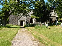
 St Petroc's Church: the parish church | |
| Location | |
| Grid reference: | SX63835946 |
| Location: | 50°25’8"N, 3°55’7"W |
| Data | |
| Population: | 77 (2001) |
| Post town: | Ivybridge |
| Postcode: | PL21 |
| Dialling code: | 01548 |
| Local Government | |
| Council: | South Hams |
| Parliamentary constituency: |
South West Devon |
Harford is a hamlet some two miles north of the tiny town of Ivybridge in southern Devon. It is on Dartmoor, on the southern slopes of the moor, which are rich here in the remains of ancient times, with hut circles, cairns and a stone row. The village is on the River Erme, which runs down from here to Ivybridge.
Though with a population of just 77 people, Harford also forms a civil parish.

Outside links
| ("Wikimedia Commons" has material about Harford) |
