Mathon: Difference between revisions
Jump to navigation
Jump to search
Created page with "{{Infobox town |name=Mathon |county=Worcestershire |picture=Lych gate to Mathon Church - geograph.org.uk - 775582.jpg |picture caption=Lych gate to Mathon Church |os grid ref=..." |
No edit summary |
||
| Line 5: | Line 5: | ||
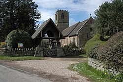
|picture caption=Lych gate to Mathon Church | |picture caption=Lych gate to Mathon Church | ||
|os grid ref=SO734458 | |os grid ref=SO734458 | ||
|latitude=52. | |latitude=52.109881 | ||
|longitude=-2. | |longitude=-2.389825 | ||
|population= | |population= | ||
|census year=2001 | |census year=2001 | ||
Revision as of 09:32, 29 August 2018
| Mathon | |
| Worcestershire | |
|---|---|
 Lych gate to Mathon Church | |
| Location | |
| Grid reference: | SO734458 |
| Location: | 52°6’36"N, 2°23’23"W |
| Data | |
| Post town: | Malvern |
| Postcode: | WR13 |
| Local Government | |
| Council: | Herefordshire |
Mathon is a village and parish in western Worcestershire close to the border with Herefordshire. It lies in the lower division of the hundred of Pershore, two miles west of Great Malvern and seven miles north-east of Ledbury. The village, which is small, is situated on Cradley Brook, near the Malvern Hills.

This Worcestershire article is a stub: help to improve Wikishire by building it up.