Difference between revisions of "An Sgurr (Lochcarron)"
From Wikishire
(Created page with "{{Infobox hill |name=An Sgùrr |county=Ross |picture=An Sgurr - summit cairn - geograph.org.uk - 140576.jpg |picture caption=Cairn at the summit of An Sgùrr |height=1,286 ft...") |
(No difference)
|
Latest revision as of 10:17, 31 March 2018
| An Sgùrr | |
| Ross-shire | |
|---|---|
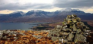
 Cairn at the summit of An Sgùrr | |
| Summit: | 1,286 ft NG857387 57°23’17"N, 5°34’3"W |
An Sgùrr is a hill in the parish of Lochcarron in western Ross-shire, occupying the broad peninsula between Loch Carron and Loch Kishorn. It has the appearance of a rough knoll, with small crags ringing the summit, particularly on the western side.
The hill may be climbed from a number of locations. The A896 road passes roughly a mile to the north, whilst a forestry track from south of Lochcarron allows access to the south-east. The path between Achintraid and Reraig passes to the south west side of An Sgùrr; the summit may be reached from Bealach that separates An Sgùrr from Bad a' Chreamha, which lies a mile or so east of this path.
This Mountain or hill article is a stub: help to improve Wikishire by building it up.