Cupidstown Hill: Difference between revisions
Jump to navigation
Jump to search
Created page with '{{Infobox hill |name=Cupidstown Hill |county=County Kildare |range=Wicklow Mountains |picture=Trig point at summit of Cupidstown Hill - geograph.org.uk - 223982.jpg |picture capt…' |
No edit summary |
||
| Line 7: | Line 7: | ||
|height=1,243 feet | |height=1,243 feet | ||
|os grid ref=O00572060 | |os grid ref=O00572060 | ||
|latitude=53.22654 | |||
|longitude=-6.49485 | |||
}} | }} | ||
'''Cupidstown Hill''' is a hill in north-eastern [[County Kildare]], on the fringes of the [[Wicklow Mountains]]. At 1,243 feet, it is the [[County top|highest summit]] in Kildare, almost twice as high as the [[Hill of Allen]]. | '''Cupidstown Hill''' is a hill in north-eastern [[County Kildare]], on the fringes of the [[Wicklow Mountains]]. At 1,243 feet, it is the [[County top|highest summit]] in Kildare, almost twice as high as the [[Hill of Allen]]. | ||
Latest revision as of 10:44, 27 March 2018
| Cupidstown Hill | |||
| County Kildare | |||
|---|---|---|---|
 Cnoc Bhaile Cupid | |||
| Range: | Wicklow Mountains | ||
| Summit: | 1,243 feet O00572060 53°13’36"N, 6°29’41"W | ||
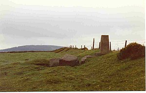
Cupidstown Hill is a hill in north-eastern County Kildare, on the fringes of the Wicklow Mountains. At 1,243 feet, it is the highest summit in Kildare, almost twice as high as the Hill of Allen.
The hill is named after the townland of Cupidstown. In the Irish language likewise it is known as Cnoc Bhaile Cupid, which is mere translation. The hill stands just above the village of Kilteel.
Notwithstanding its height, Cupidstown Hill is lesser known than other summits in Kildare as it is dwarfed by nearby mountains across the county border such as Kippure, in the counties of Dublin and Wicklow.