Alarm Forest: Difference between revisions
Created page with "right|thumb|300px|The view from James Bay: Alarm Forest and Briars Village behind Jamestown File:Districts of St Helena.svg|thumb|ri..." |
No edit summary |
||
| Line 1: | Line 1: | ||
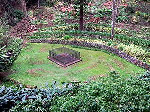
[[File: | [[File:Napoleon's Grave (16502460875).jpg|right|thumb|300px|Napoleon's Grave in the Alarm Forest]] | ||
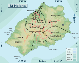
[[File:Districts of St Helena.svg|thumb|right|St Helena and its districts]] | [[File:Districts of St Helena.svg|thumb|right|St Helena and its districts]] | ||
{{county|St Helena, Ascension and Tristan da Cunha}} | {{county|St Helena, Ascension and Tristan da Cunha}} | ||
'''Alarm Forest''' is one of the smaller of the eight districts of [[St Helena]], in the northern part of the island, southeast of [[Jamestown, St Helena|Jamestown]]. In 2008 the district had a population of 276. | '''Alarm Forest''' is one of the smaller of the eight districts of [[St Helena]], in the northern part of the island, southeast of [[Jamestown, St Helena|Jamestown]]. In 2008 the district had a population of 276. | ||
There is no village named "Alarm Forest": the main settlement is [[Briars Village]].<ref>[http://issuu.com/magma/docs/full_document_final/100 Issu.com] Spatial identities of the citizens of St Helena</ref> The district was created between census years 1987 and 1998 from parts of [[Jamestown, St Helena|Jamestown]] and [[Longwood, St Helena|Longwood]]. | There is no village named "Alarm Forest": the name is from the forest which surrounds Alarm House (now a private house) standing in a prominent position overlooking James Bay. Alarm House was so named because until 1692 two guns were stationed on this hilltop, which were fired to raise the alarm whenever unknown ships were sighted in James Bay.<ref>[http://sainthelenaisland.info/alarmforest.htm#alarmhouse St Helena Island - Alarm Forest]</ref> | ||
The main settlement in the district is [[Briars Village]].<ref>[http://issuu.com/magma/docs/full_document_final/100 Issu.com] Spatial identities of the citizens of St Helena</ref> The district was created between census years 1987 and 1998 from parts of [[Jamestown, St Helena|Jamestown]] and [[Longwood, St Helena|Longwood]]. | |||
Briars Village is to be found at the high point of the Side Path, a steep road leading out southward on the eastern slopes of Jamestown valley. Briars Village is considered effectively a suburb of Jamestown, with few amenities of its own, while the wider district is a wilder country area of forest and valleys. | Briars Village is to be found at the high point of the Side Path, a steep road leading out southward on the eastern slopes of Jamestown valley. Briars Village is considered effectively a suburb of Jamestown, with few amenities of its own, while the wider district is a wilder country area of forest and valleys. | ||
Also within this district are Seaview, Two-gun Saddle and Hunts Vale.<ref>[http://www.tps.co.sh/Locations.htm The Property Shop] General locations in St Helena</ref> Another area of settlement is Alarm Hill, where the historic [[Alarm House]] stands. | Also within this district are Seaview, Two-gun Saddle and Hunts Vale.<ref>[http://www.tps.co.sh/Locations.htm The Property Shop] General locations in St Helena</ref> Another area of settlement is Alarm Hill, where the historic [[Alarm House]] stands. The famed [[Heart Shaped Waterfall]] is within the district too. | ||
Napoleon's tomb (now empty) is to be found in the [[Valley of the Tomb]], part of Sane Valley, in the district. Napoleon had selected this spot as his burial site during one of his walks. He was later reburied in Les Invalides in Paris. | Napoleon's tomb (now empty) is to be found in the [[Valley of the Tomb]], part of Sane Valley, in the district. Napoleon had selected this spot as his burial site during one of his walks. He was later reburied in Les Invalides in Paris. | ||
Latest revision as of 10:25, 8 February 2018


Alarm Forest is one of the smaller of the eight districts of St Helena, in the northern part of the island, southeast of Jamestown. In 2008 the district had a population of 276.
There is no village named "Alarm Forest": the name is from the forest which surrounds Alarm House (now a private house) standing in a prominent position overlooking James Bay. Alarm House was so named because until 1692 two guns were stationed on this hilltop, which were fired to raise the alarm whenever unknown ships were sighted in James Bay.[1]
The main settlement in the district is Briars Village.[2] The district was created between census years 1987 and 1998 from parts of Jamestown and Longwood.
Briars Village is to be found at the high point of the Side Path, a steep road leading out southward on the eastern slopes of Jamestown valley. Briars Village is considered effectively a suburb of Jamestown, with few amenities of its own, while the wider district is a wilder country area of forest and valleys.
Also within this district are Seaview, Two-gun Saddle and Hunts Vale.[3] Another area of settlement is Alarm Hill, where the historic Alarm House stands. The famed Heart Shaped Waterfall is within the district too.
Napoleon's tomb (now empty) is to be found in the Valley of the Tomb, part of Sane Valley, in the district. Napoleon had selected this spot as his burial site during one of his walks. He was later reburied in Les Invalides in Paris.
References
- ↑ St Helena Island - Alarm Forest
- ↑ Issu.com Spatial identities of the citizens of St Helena
- ↑ The Property Shop General locations in St Helena