Exning: Difference between revisions
Created page with "{{Infobox town |county=Suffolk |population=1,960 |census year=2011<ref>{{cite web|url=http://neighbourhood.statistics.gov.uk/dissemination/LeadKeyFigures.do?a=7&b=11123299&c=e..." |
No edit summary |
||
| Line 11: | Line 11: | ||
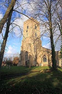
|picture caption= Church of St Martin, Exning | |picture caption= Church of St Martin, Exning | ||
}} | }} | ||
'''Exning''' is a village and parish in [[Suffolk]], adjacent to [[Newmarket]] in that part of the county that projects into [[Cambridgeshire]]. The ancient parish, along with that of Newmarket St Mary comprise the 'bubble'. | '''Exning''' is a village and parish in [[Suffolk]], adjacent to [[Newmarket]], in that part of the county that projects into [[Cambridgeshire]]. The ancient parish, along with that of Newmarket St Mary, comprise the 'bubble', with the westernmost part of the parish forming the westernmost part of Suffolk. | ||
The village lies just off the A14 trunk road, roughly 12 miles east-north-east of [[Cambridge]], and 10 miles south-south-east of [[Ely, Cambridgeshire|Ely]]. The nearest large town is Newmarket. | |||
The most conspicuous building in Exning is the church of St Martin, which is visible from the A14. | The most conspicuous building in Exning is the church of St Martin, which is visible from the A14. | ||
| Line 38: | Line 38: | ||
*[http://www.exningparishchurch.net/ Exning Parish Churches] | *[http://www.exningparishchurch.net/ Exning Parish Churches] | ||
*[http://www.jrsaville.co.uk/Exning_walk.htm A Walk Round Exning] | *[http://www.jrsaville.co.uk/Exning_walk.htm A Walk Round Exning] | ||
[[Category:Extreme points of Suffolk]] | |||
Latest revision as of 16:06, 5 September 2017
| Exning | |
| Suffolk | |
|---|---|
 Church of St Martin, Exning | |
| Location | |
| Location: | 52°16’0"N, -0°21’0"E |
| Data | |
| Population: | 1,960 (2011[1]) |
| Post town: | Newmarket |
| Postcode: | CB8 |
| Local Government | |
| Council: | West Suffolk |
Exning is a village and parish in Suffolk, adjacent to Newmarket, in that part of the county that projects into Cambridgeshire. The ancient parish, along with that of Newmarket St Mary, comprise the 'bubble', with the westernmost part of the parish forming the westernmost part of Suffolk.
The village lies just off the A14 trunk road, roughly 12 miles east-north-east of Cambridge, and 10 miles south-south-east of Ely. The nearest large town is Newmarket.
The most conspicuous building in Exning is the church of St Martin, which is visible from the A14.
History
Local lore reputes Exning to have been the capital of the Iceni tribe and therefore the home of Queen Boadicea (Boudicca).[2]
Since the time of William the Conqueror, Exning has formed part of Lackford Hundred. Later the hundred was a part of the Liberty of Ely.
Exning is reputed to have been the birthplace of Saint Ethelreda, to whom the cathedral at Ely is dedicated, though this is disputed.
During the Second World War, the headquarters of No 3 Group of RAF Bomber Command were located in Exning House. Nearby Newmarket Heath, the northwest corner of which borders on Exning, was used as an airfield for, amongst others, Stirling III Bombers of No. 75 (NZ) Squadron RAF. Little evidence remains of this chapter in Exning's history, apart from a single aircraft hangar on Heath Road, Burwell (near the "One Thousand Guineas Connect" service station on the A14 trunk road) and a memorial plaque on the racecourse.
References
- ↑ "Civil Parish population 2011". Neighbourhood Statistics. Office for National Statistics. http://neighbourhood.statistics.gov.uk/dissemination/LeadKeyFigures.do?a=7&b=11123299&c=exning&d=16&e=62&g=6465797&i=1001x1003x1032x1004&o=362&m=0&r=1&s=1471701401547&enc=1. Retrieved 20 August 2016.
- ↑ http://www.exningparishchurch.net/history_village.htm
Outside links
| ("Wikimedia Commons" has material about Exning) |
