Billericay: Difference between revisions
m →Sport |
mNo edit summary |
||
| Line 14: | Line 14: | ||
|constituency=Basildon and Billericay | |constituency=Basildon and Billericay | ||
}} | }} | ||
'''Billericay''' is a town in southern [[Essex]] with a population of around 60,000. It is a commuter town for [[London]] 28 miles away. The town is in appearance | '''Billericay''' is a town in southern [[Essex]] with a population of around 60,000. It is a commuter town for [[London]] 28 miles away. The town is in appearance of modern development, but its origin is ancient and indeed these acres are thought to have been occupied since the Bronze Age. | ||
==History== | ==History== | ||
Latest revision as of 13:30, 23 July 2017
| Billericay | |
| Essex | |
|---|---|
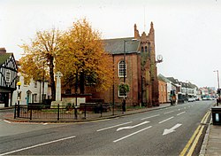
 Billericay High Street and St Mary Magdalen Church | |
| Location | |
| Grid reference: | TQ675945 |
| Location: | 51°37’41"N, -0°25’6"E |
| Data | |
| Population: | 60,000 |
| Post town: | Billericay |
| Postcode: | CM11, CM12 |
| Dialling code: | 01277 |
| Local Government | |
| Council: | Basildon |
| Parliamentary constituency: |
Basildon and Billericay |
Billericay is a town in southern Essex with a population of around 60,000. It is a commuter town for London 28 miles away. The town is in appearance of modern development, but its origin is ancient and indeed these acres are thought to have been occupied since the Bronze Age.
History
Some of the earliest records of human occupation of Billericay are the burial mounds in Norsey Wood: evidence of occupation in the Bronze and Iron Ages. Evidence of Roman occupation has been found at a number of locations in the town and there may have been a small cavalry fort at Blunts Wall.
The Saxons did not settle early in the centre of Billericay but established themselves two miles south, at Great Burstead, recorded in the late 10th century as Burhstede. Billericay is not mentioned in the Domesday Book of 1086 as it lay within Great Burstead manor and at this time the parish church for Billericay was at Great Burstead. In 1291 the name Byllyrica is first recorded, believed to be from a mediæval Latin word, bellerīca, meaning 'dyehouse or tanhouse'.[1]
Middle Ages

In the 13th and 14th centuries some pilgrims to Canterbury journeyed by way of Billericay. Some of them may have spent the night in Billericay before crossing the River Thames at Tilbury. Which may account for the large number of inns in the town.
On 28 June 1381 King Richard II's soldiers defeated Essex rebels at Norsey Wood near the town and about 500 rebels were killed in the battle, which ended the Peasants' Revolt.
The Wycliffe preachers influenced the town. Four local people (Thomas Watts, Joan Hornes, Elizabeth Thackwell, and Margaret Ellis) were burnt at the stake. Two other residents (Joan Potter and James Harris) were tortured for their faith during the reign of Queen Mary.
The Pilgrim Fathers
A meeting of the Pilgrim Fathers before they set sail in the Mayflower is said to have taken place in Billericay, and many local names and much historical imagery reflect this: Mayflower House, Morris Men, Taxis, School, Hall. Sunnymede School's houses were called Mayflower, Pilgrim, Chantry and Martin (after Christopher Martin, a Billericay merchant who travelled on the Mayflower as Ship's Governor).
Four people from Billericay were aboard, including Christopher Martin. He and his wife Marie, along with Solomon Prowe and John Langemore, perished shortly after their arrival at Cape Cod, Massachusetts.
The unfortunate fate of the would-be pioneers did not deter other inhabitants of Billericay from setting sail for the New World. The town of Billerica, Massachusetts was established in 1655 and named to commemorate the origins of some of the first settlers.
Georgian and Victorian eras
In the Georgian period many excellent examples of the period's houses were built in Billericay. One of those remaining today is Burghstead Lodge in High Street, which used to house the library. The road from Billericay to Tilbury still had a reputation for footpads and highwaymen operating along the road, where it passed through open country.
In the town, the Union Workhouse was built in 1840 to continue to implement the Poor Law. Parts of this building were later incorporated into what was St. Andrew's Hospital. The railway arrived in Billericay in 1889, being on the Great Eastern Main Line between London and Southend-on-Sea.
The 20th century
In 1916, during the First World War, one of the giant German Zeppelin airships was shot down during an aerial battle over Billericay. During its fiery demise, it narrowly missed the High Street, crashing into a nearby field. Recent research has indicated that this may be identified with the 'ghost Zeppelin' of Tonbridge which was allegedly seen floating over that town earlier in the day.
St. Andrew's Hospital, which was formerly the site of the town's Victorian workhouse, continued to function as an important communal building. From 1973, it housed the internationally renowned Regional Plastic Surgery and Burns unit until this was relocated to Broomfield Hospital, Chelmsford in April 1998. After the relocation, most of the hospital was redeveloped into housing. The listed buildings remain intact but are now residential.
Geography

Billericay is within the London Basin and lies on a mixture of London clay, Claygate Beds and Bagshot Beds. Near the High Street, there is a change in soil type from sandy to clay, which gives rise to local underground springs. Open spaces include Norsey Wood, Mill Meadows Nature Reserve, Queen's Park Country Park, Sun Corner, Lake Meadows, Hanningfield Reservoir and South Green.
Transport
Billericay is a part of the London commuter belt. It is served by Billericay railway station route from Liverpool Street station in the City of London, to Southend on Sea. The station connects to local bus routes.
Billericay is close to two primary roads: the A12 to the north and the A127 in the south. The A176 provides a road link to Basildon to the south of Billericay, as well as to the A127. The only secondary road in the town, the B1007, passes from just south of the town centre as Laindon Road, meets the A129 at Sun Corner and then continues northwards as Billericay's High Street and then Stock Road. It continues north to the county town of Chelmsford. Along its route is the village of Stock and an interchange to the A12. The town is a destination on the A129, linking it to the neighbouring towns of Brentwood and Wickford.
Sport

- Cricket: Billericay Cricket Club
- Football: Billericay Town
- Rugby: Billericay Rugby Football Club
Culture
The town has not fared well in popular culture. The song by Ian Dury and the Blockheads "Billericay Dickie" is hardly complimentary. Billericay is also mentioned in George Orwell's novel Down and Out in Paris and London. Billericay is also the setting of the BBC sitcom Gavin & Stacey as the home of Gavin Shipman (Mathew Horne) and his parents, though the actual filming took place in Glamorgan.
The Cater Museum is a privately owned local history museum housed in an 18th & 19th century building in the High Street.
Outside links
| ("Wikimedia Commons" has material about Billericay) |
- Local Interest in and Around Billericay 6 December 2007.
- The Billericay Society – Retrieved 9 November 2006.
- Wyn Grant's Billericay Page – Retrieved 9 November 2006.
- www.billericayessex.co.uk – Latest local news, events and business directory – 1 February 2011.
- Billericay Round Table
References
- ↑ 'Oxford Dictionary of British Place-Names', A.D. Mills, Oxford University Press
