Boreland, Fife: Difference between revisions
Jump to navigation
Jump to search
Created page with "{{Infobox town |name=Boreland |county=Fife |picture= |picture caption= |os grid ref= NT304943 |latitude=56.136811 |longitude=-3.121467 |postcode= KY1 |post town= |population=..." |
mNo edit summary |
||
| Line 2: | Line 2: | ||
|name=Boreland | |name=Boreland | ||
|county=Fife | |county=Fife | ||
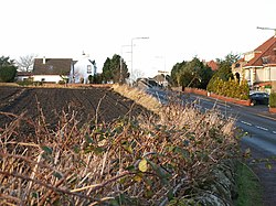
|picture= | |picture=Boreland - geograph.org.uk - 100250.jpg | ||
|picture caption= | |picture caption= | ||
|os grid ref= NT304943 | |os grid ref= NT304943 | ||
Latest revision as of 12:00, 25 March 2017
| Boreland | |
| Fife | |
|---|---|

| |
| Location | |
| Grid reference: | NT304943 |
| Location: | 56°8’13"N, 3°7’17"W |
| Data | |
| Postcode: | KY1 |
| Local Government | |
| Council: | Fife |
Boreland is a hamlet at the eastern edge of Kirkcaldy in Fife, strung along the B929, and squashed against the northbound railway line, immediately north of Dysart.
There is an industrial estate here, across the tracks.