Upminster: Difference between revisions
Jump to navigation
Jump to search
Created page with '{{Infobox town | name= Upminster | county = Essex | picture = Upminster_Windmill_027.jpg | picture caption= Upminster Windmill | os grid ref= TQ560865 | latitude= 51.555743 | lon…' |
No edit summary |
||
| Line 18: | Line 18: | ||
{{stub}} | {{stub}} | ||
[[Category:Metropolitan Essex]] | |||
Revision as of 18:01, 18 February 2017
| Upminster | |
| Essex | |
|---|---|
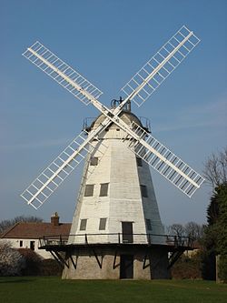
 Upminster Windmill | |
| Location | |
| Grid reference: | TQ560865 |
| Location: | 51°33’21"N, -0°15’4"E |
| Data | |
| Population: | 25,361 (2011) |
| Post town: | Upminster |
| Postcode: | RM14 |
| Dialling code: | 01708 |
| Local Government | |
| Council: | Havering |
| Parliamentary constituency: |
Hornchurch and Upminster |
Upminster is a town in Essex, located at the eastern edge of the Greater London conurbation. It is home to the eastern terminus of the District Line of the London Underground. Upminster Windmill, formerly known as Abraham's Mill, is a smock mill and one of the few surviving windmills in England. The speed of sound was first calculated accurately by the Reverend William Derham in Upminster.

This Essex article is a stub: help to improve Wikishire by building it up.