Hurkar Rocks: Difference between revisions
Created page with "right|thumb|300px|The Hurkar Rocks: Hurker and Buss Crag {{county|Berwickshire}} The '''Hurkar Rocks''' are a gr..." |
No edit summary |
||
| Line 1: | Line 1: | ||
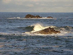
[[File:Reefs in Eyemouth Bay - geograph.org.uk - 1078954.jpg|right|thumb|300px|The Hurkar Rocks: Hurker and Buss Crag]] | [[File:Reefs in Eyemouth Bay - geograph.org.uk - 1078954.jpg|right|thumb|300px|The Hurkar Rocks: Hurker and Buss Crag]] | ||
{{county|Berwickshire}} | {{county|Berwickshire}} | ||
The '''Hurkar Rocks''' are a group of rocks outside the harbour of [[Eyemouth]] in the [[Berwickshire]]. The rocks become exposed during low tide, and at all tides are a hazard to ships | The '''Hurkar Rocks''' are a group of rocks outside the harbour of [[Eyemouth]] in the [[Berwickshire]]. The rocks become exposed during low tide, and at all tides are a hazard to ships approaching or leaving the harbour. | ||
The original of the rocks’ name is unknown, but records | The original of the rocks’ name is unknown, but records show them named variously as ''Hurkur'', ''Hurker'', ''Hurkar'', ''Harkar'', and ''Buss Craig Rock''. | ||
During the Eyemouth Disaster of 1881, a number of ships, returning from out of the storm, were wrecked upon these rocks. One of these was classified as an iron steamship, with a cargo of wheat. The date of loss was cited as 2 December 1894. | During the Eyemouth Disaster of 1881, a number of ships, returning from out of the storm, were wrecked upon these rocks. One of these was classified as an iron steamship, with a cargo of wheat. The date of loss was cited as 2 December 1894. | ||
| Line 11: | Line 11: | ||
==Outside links== | ==Outside links== | ||
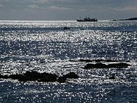
[[File:North Sea off Eyemouth - geograph.org.uk - 18084.jpg|right|thumb|200px|Off Eyemouth Harbour]] | [[File:North Sea off Eyemouth - geograph.org.uk - 18084.jpg|right|thumb|200px|Off Eyemouth Harbour]] | ||
*Location map: {{wmap|55.8782|-2.0856|zoom=14}} | *Location map: {{wmap|55.8782|-2.0856|zoom=14|name=Hurkar Rocks}} | ||
*[http://www.scran.ac.uk/database/record.php?usi=000-000-484-805-C SCRAN File: Eyemouth Tapestry] | *[http://www.scran.ac.uk/database/record.php?usi=000-000-484-805-C SCRAN File: Eyemouth Tapestry] | ||
*[http://heritage.scotsman.com/disasterstrikes/When-the-seas-swallowed-Scotlands.2743058.jp The Scotsman, January 2006: "When the seas swallowed Scotland's fishermen"] | *[http://heritage.scotsman.com/disasterstrikes/When-the-seas-swallowed-Scotlands.2743058.jp The Scotsman, January 2006: "When the seas swallowed Scotland's fishermen"] | ||
Revision as of 09:54, 5 November 2016

The Hurkar Rocks are a group of rocks outside the harbour of Eyemouth in the Berwickshire. The rocks become exposed during low tide, and at all tides are a hazard to ships approaching or leaving the harbour.
The original of the rocks’ name is unknown, but records show them named variously as Hurkur, Hurker, Hurkar, Harkar, and Buss Craig Rock.
During the Eyemouth Disaster of 1881, a number of ships, returning from out of the storm, were wrecked upon these rocks. One of these was classified as an iron steamship, with a cargo of wheat. The date of loss was cited as 2 December 1894.
The Eyemouth Tapestry was sewn by 24 local ladies and took years to complete. With the help of the Eyemouth Museum Trust, the Eyemouth Tapestry is on display at the Eyemouth Maritime Centre.
Outside links

- Location map: 55°52’42"N, 2°5’8"W
- SCRAN File: Eyemouth Tapestry
- The Scotsman, January 2006: "When the seas swallowed Scotland's fishermen"
- BBC: Eyemouth Fishing Disaster
- Diving at Hurker Rock, Eyemouth